 Filter: Categories of Wisconsin Historical Images
Filter: FULL_DATE of 1906
Filter: Subject of cable cars (streetcars)
Filter: Categories of Wisconsin Historical Images
Filter: FULL_DATE of 1906
Filter: Subject of cable cars (streetcars)
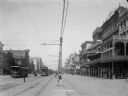
| Date: | 1906 |
|---|---|
| Description: | View down Canal Street in New Orleans. View is toward the lake from Camp/Chartres Streets. The first building on the right reads "May's Drug Store". The tw... |

| Date: | 1906 |
|---|---|
| Description: | This map shows ward boundaries, subdivisions, lot and block numbers and dimensions, house numbers, electric car lines, steam railways, and adjoining plat n... |

| Date: | 1906 |
|---|---|
| Description: | This map shows ward boundaries, lot and block numbers and dimensions, house numbers, electric car lines, steam railways, and adjoining plat numbers in a po... |
If you didn't find the material you searched for, our Library Reference Staff can help.
Call our reference desk at 608-264-6535 or email us at: