 Filter: Categories of Wisconsin Historical Images
Filter: FULL_DATE of 1905
Filter: Community of Madison
Filter: Subject of roads
Filter: Categories of Wisconsin Historical Images
Filter: FULL_DATE of 1905
Filter: Community of Madison
Filter: Subject of roads
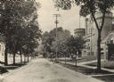
| Date: | 1905 |
|---|---|
| Description: | Langdon Street and the lower campus of the University of Wisconsin, including the Armory (Red Gym or Old Red). |

| Date: | 1905 |
|---|---|
| Description: | Elevated view from the Wisconsin State Capitol of State Street looking west, toward the University of Wisconsin-Madison and Bascom Hall. |
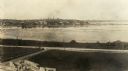
| Date: | 1905 |
|---|---|
| Description: | Elevated view looking towards the Wisconsin State Capitol from across Monona Bay. |
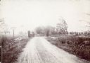
| Date: | 1905 |
|---|---|
| Description: | The rustic bridge on Lake Mendota Drive, over a ravine in Shorewood Hills. The sign on the left reads: "$5 FINE, For riding or driving over this bridge fas... |
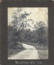
| Date: | 1905 |
|---|---|
| Description: | The rustic iron bridge on University Drive. The sign on the left advertises a $25.00 Reward. Lake Mendota is visible on the right. |

| Date: | 1905 |
|---|---|
| Description: | This map shows roads, railroads, and location of Keyes Springs, now part of Monona. The map reads: "L.S. Smith, c.e., del. May, 1905" and "For further info... |
| Date: | 1905 |
|---|---|
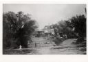
| Description: | View from Lake Mendota of the Turner residence at 629 Frances Street. A woman is standing on the shoreline. |

| Date: | 1905 |
|---|---|
| Description: | This blueprint map includes manuscript annotations in red showing land of Home Realty Co., Hon. Geo. B. Burrows, and A.O. Fox Industrial. |
If you didn't find the material you searched for, our Library Reference Staff can help.
Call our reference desk at 608-264-6535 or email us at: