 Filter: Categories of Wisconsin Historical Images
Filter: FULL_DATE of 1904
Filter: Subject of streets
Filter: Categories of Wisconsin Historical Images
Filter: FULL_DATE of 1904
Filter: Subject of streets
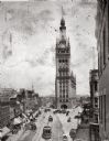
| Date: | 1904 |
|---|---|
| Description: | Elevated view of City Hall and North Water Street in downtown Milwaukee. |
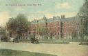
| Date: | 1904 |
|---|---|
| Description: | View across street toward the hospital, with horses and carriages along the curb in the foreground. Caption reads: "St. Vincent's Hospital, Green Bay, Wis.... |
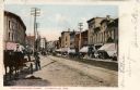
| Date: | 1904 |
|---|---|
| Description: | View down left side of street towards the right side of the street. A man is on a horse-drawn wagon in the left foreground. Storefronts are on the right. C... |
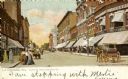
| Date: | 1904 |
|---|---|
| Description: | View down street. Horse-drawn vehicles and pedestrians are on the street and sidewalks. Streetcars are further down the street. Caption reads: "Fourth St. ... |

| Date: | 1904 |
|---|---|
| Description: | This map shows a plat of the east part of the city, numbered blocks and lots, some landownership, local streets, roads, railroads, wards by number, parks, ... |

| Date: | 1904 |
|---|---|
| Description: | This map shows a plat of the west part of the city, numbered blocks and lots, some landownership, local streets, roads, railroads, wards by number, parks, ... |

| Date: | 1904 |
|---|---|
| Description: | Elevated view looking north on N. Water Street toward City Hall. The streets are filled with automobiles and streetcars. Sidewalks are bustling with pedest... |
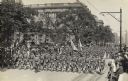
| Date: | 1904 |
|---|---|
| Description: | Slightly elevated view of soldiers marching in a parade down a street. Spectators fill the sidewalks. |

| Date: | 1904 |
|---|---|
| Description: | View of First M.E. Church, partially obscured by trees. The church has two entrances along the frontside, one of which is part of the bell tower. |

| Date: | 1904 |
|---|---|
| Description: | This map shows numbered wards and plots, labelled streets, and parks in green. |

| Date: | 1904 |
|---|---|
| Description: | This map is mounted on cloth and shows streets, railways, and city wards. A stamp in the right margin reads: "The Library of Congress, one copy received Fe... |

| Date: | 1904 |
|---|---|
| Description: | This map has three inset maps of Whitefish Bay, Cudahy, and South Milwaukee. This map depicts schools, engine houses, railroads, street railways, city ward... |

| Date: | 1904 |
|---|---|
| Description: | This map shows wards, schools, engine houses, railroads, street railways, block numbers, parks, roads, and Lake Michigan. Also included are indexes: Table ... |

| Date: | 1904 |
|---|---|
| Description: | Map showing lots, additions, and wards within the city limits, as well as some landownership. The streets are labeled, as is Lake Winnebago, rivers, railro... |

| Date: | 1904 |
|---|---|
| Description: | Dorothy Fargo, ten years old, is holding the hands of her brothers Frank, four years old, and Stuart, seven years old, as they are posing on the sidewalk a... |

| Date: | 1904 |
|---|---|
| Description: | View from street towards a house along Langdon Street, with Lake Mendota in the background. Caption reads: "Home of my sister Sophie and family at 10 Langd... |

| Date: | 1904 |
|---|---|
| Description: | View overlooking Iron River in winter. Several residences, and yards with fences are in the foreground. Wooded hills are in the far background. |

| Date: | 1904 |
|---|---|
| Description: | View of the courthouse, with an arched entrance and clock tower. Caption reads: "Court House, La Crosse, Wis." |
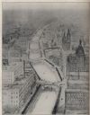
| Date: | 1904 |
|---|---|
| Description: | Alfred Clas design drawing of a scheme for the improvement of the Milwaukee River, with possibilities of narrowing the river and paralleling the banks with... |
If you didn't find the material you searched for, our Library Reference Staff can help.
Call our reference desk at 608-264-6535 or email us at:
