Filter: Categories of Wisconsin Historical Images
Filter: FULL_DATE of 1904
Filter: Subject of rivers
Filter: Categories of Wisconsin Historical Images
Filter: FULL_DATE of 1904
Filter: Subject of rivers
| Date: | 1904 |
|---|---|
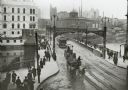
| Description: | Elevated view of wagons hauling coal from the Milwaukee Western Fuel Company holding up street car traffic on a busy Milwaukee street. |
| Date: | 1904 |
|---|---|
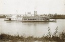
| Description: | The sidewheel excursion, Saint Paul, on the Mississippi River near Lansing, Iowa. Later named the Senator. Small boats are line up on a pier ... |
| Date: | 1904 |
|---|---|
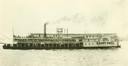
| Description: | The sidewheel excursion, Saint Paul, underway. Sign on wheel reads: "St. Louis, Dubuque, St. Paul, Diamond Jo Line." Later named the Senator. |
| Date: | 1904 |
|---|---|
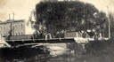
| Description: | View across Yahara River towards a group of people on the Sherman Avenue Bridge, with the old malt house in the background. |
| Date: | 1904 |
|---|---|
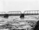
| Description: | Logs floating down the river beneath the bridge on the Chippewa River. On the far shoreline are billboards. One advertises for "J.R. Sharp Hardware." Men a... |
| Date: | 1904 |
|---|---|
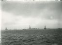
| Description: | New York Harbor, with the Statue of Liberty and various boats. |
| Date: | 1904 |
|---|---|
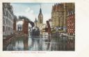
| Description: | Colored view of the river lined with buildings. The drawbridge is raised as a steamboat is passing through. There is a clocktower in the background. Captio... |
| Date: | 1904 |
|---|---|
| Description: | A view looking west over water toward the Fox River dam at Montello. There is granite riprap on the left. A boat with a small sail is in the background. T... |

| Date: | 1904 |
|---|---|
| Description: | Logs floating down the Chippewa River in front of the "Big Mill". |

| Date: | 1904 |
|---|---|
| Description: | A map that shows the location of the lakes and resorts in northeastern Wisconsin that were reachable by the Chicago and North Western Railway. Shown in the... |

| Date: | 1904 |
|---|---|
| Description: | A business map of Wisconsin also including the western portion of Michigan's Upper Peninsula, eastern Iowa and Minnesota, and northern Illinois, showing, r... |

| Date: | 1904 |
|---|---|
| Description: | A brochure for the lake region of north-eastern Illinois and south-eastern Wisconsin providing information on summer activities and places to stay in the a... |

| Date: | 1904 |
|---|---|
| Description: | This map shows lakes, railroads, and rivers. Also includes an explanation of railroad lines and mileage and a table showing miles from cities to Milwaukee.... |

| Date: | 1904 |
|---|---|
| Description: | This map has three inset maps of Whitefish Bay, Cudahy, and South Milwaukee. This map depicts schools, engine houses, railroads, street railways, city ward... |

| Date: | 1904 |
|---|---|
| Description: | Map showing lots, additions, and wards within the city limits, as well as some landownership. The streets are labeled, as is Lake Winnebago, rivers, railro... |
| Date: | 1904 |
|---|---|
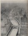
| Description: | Alfred Clas design drawing of a scheme for the improvement of the Milwaukee River, with possibilities of narrowing the river and paralleling the banks with... |
| Date: | 1904 |
|---|---|
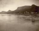
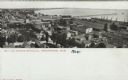
| Description: | Elevated view of Manitowoc and Lake Michigan. Caption reads: "Bay and Harbor Entrance, Manitowoc, Wis." |

| Date: | 1904 |
|---|---|
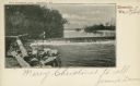
| Description: | View across a body of water toward several buildings along a shoreline. Caption reads: "Main Street, Necedah, Wis. looking south from the residence of Dr. ... |
If you didn't find the material you searched for, our Library Reference Staff can help.
Call our reference desk at 608-264-6535 or email us at: