 Filter: Categories of Wisconsin Historical Images
Filter: FULL_DATE of 1904
Filter: Subject of parks
Filter: Categories of Wisconsin Historical Images
Filter: FULL_DATE of 1904
Filter: Subject of parks

| Date: | 1904 |
|---|---|
| Description: | Postcard depicting the fire of February 26-27, 1904 that destroyed most of the second Wisconsin State Capitol. The smoke and flames have been dramatically ... |

| Date: | 1904 |
|---|---|
| Description: | This map shows a plat of the east part of the city, numbered blocks and lots, some landownership, local streets, roads, railroads, wards by number, parks, ... |

| Date: | 1904 |
|---|---|
| Description: | This map shows a plat of the west part of the city, numbered blocks and lots, some landownership, local streets, roads, railroads, wards by number, parks, ... |
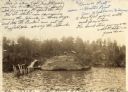
| Date: | 1904 |
|---|---|
| Description: | View across water towards Brower Park near Houghton Point. |

| Date: | 1904 |
|---|---|
| Description: | A map showing the design for a park fronting on Lake Monona Bay. (Now called Brittingham Park) taken from between pages 44 & 45 of the 1905 Madison Park a... |
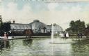
| Date: | 1904 |
|---|---|
| Description: | Fountain in front of the conservatory, separated by paths and shrubbery. Several pedestrians are standing near the fountain. Caption reads: "Conservatory, ... |
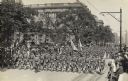
| Date: | 1904 |
|---|---|
| Description: | Slightly elevated view of soldiers marching in a parade down a street. Spectators fill the sidewalks. |

| Date: | 1904 |
|---|---|
| Description: | This map has three inset maps of Whitefish Bay, Cudahy, and South Milwaukee. This map depicts schools, engine houses, railroads, street railways, city ward... |

| Date: | 1904 |
|---|---|
| Description: | This map shows wards, schools, engine houses, railroads, street railways, block numbers, parks, roads, and Lake Michigan. Also included are indexes: Table ... |

| Date: | 1904 |
|---|---|
| Description: | Map showing lots, additions, and wards within the city limits, as well as some landownership. The streets are labeled, as is Lake Winnebago, rivers, railro... |
If you didn't find the material you searched for, our Library Reference Staff can help.
Call our reference desk at 608-264-6535 or email us at: