 Filter: Categories of Wisconsin Historical Images
Filter: FULL_DATE of 1904
Filter: Subject of cities and towns
Filter: Categories of Wisconsin Historical Images
Filter: FULL_DATE of 1904
Filter: Subject of cities and towns
| Date: | 1904 |
|---|---|
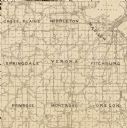
| Description: | A map of Verona, which is a detail from a map of Dane County, Wisconsin. |

| Date: | 1904 |
|---|---|
| Description: | View of First M.E. Church, partially obscured by trees. The church has two entrances along the frontside, one of which is part of the bell tower. |

| Date: | 1904 |
|---|---|
| Description: | Pathways lead through trees on a lawn to the neo-classical styled White Memorial Library, funded by Mary Flavia White. In front of the library is Birge Fou... |

| Date: | 1904 |
|---|---|
| Description: | View of the White Memorial library facade, with striped shades on the windows. A neoclassical style is visible in the columns flanking the door, the pedime... |

| Date: | 1904 |
|---|---|
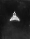
| Description: | A night view of the dome and lantern of the third Wisconsin State Capitol, lighted with electric lights. |
| Date: | 1904 |
|---|---|
| Description: | A night view of the dome and lantern of the third Wisconsin State Capitol, lighted with electric lights. |
| Date: | 1904 |
|---|---|
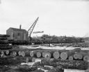
| Description: | At Hein's logging camp, a crane mounted on a railroad train lifts logs onto a flatbed railway car. Other logs are stacked on the snowy ground. A number of ... |

| Date: | 1904 |
|---|---|
| Description: | Logs floating down the Chippewa River in front of the "Big Mill". |

| Date: | 1904 |
|---|---|
| Description: | A map that shows the location of the lakes and resorts in northeastern Wisconsin that were reachable by the Chicago and North Western Railway. Shown in the... |

| Date: | 1904 |
|---|---|
| Description: | A business map of Wisconsin also including the western portion of Michigan's Upper Peninsula, eastern Iowa and Minnesota, and northern Illinois, showing, r... |

| Date: | 1904 |
|---|---|
| Description: | A brochure for the lake region of north-eastern Illinois and south-eastern Wisconsin providing information on summer activities and places to stay in the a... |

| Date: | 1904 |
|---|---|
| Description: | This 1904 map of Dane County, Wisconsin, shows postal routes, post office locations, towns, sections, cities and villages, roads, railroads, collection box... |

| Date: | 1904 |
|---|---|
| Description: | Map shows townships and sections, landownership and acreages, roads and railroads, and selected buildings. "1904" inscribed on map in pen. Includes busines... |
| Date: | 1904 |
|---|---|
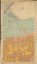
| Description: | This 1904 map from the U.S. Dept. of Agriculture's Bureau of Soils shows the soil types in north-central Douglas County, Wisconsin, and Duluth, Minnesota. ... |

| Date: | 1904 |
|---|---|
| Description: | This map shows lakes, railroads, and rivers. Also includes an explanation of railroad lines and mileage and a table showing miles from cities to Milwaukee.... |

| Date: | 1904 |
|---|---|
| Description: | This map shows numbered wards and plots, labelled streets, and parks in green. |

| Date: | 1904 |
|---|---|
| Description: | Map shows townships and sections, landownership and acreages, roads, railroads, post offices, and farms. On the top, bottom, and sides of map are advertise... |
| Date: | 1904 |
|---|---|
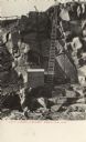
| Description: | Photographic postcard view of the bottom of the quarry, with a ladder from the bottom of the pit to top. There is a shed at the foot of the ladder. Caption... |

| Date: | 1904 |
|---|---|
| Description: | This map is mounted on cloth and shows streets, railways, and city wards. A stamp in the right margin reads: "The Library of Congress, one copy received Fe... |

| Date: | 1904 |
|---|---|
| Description: | This map has three inset maps of Whitefish Bay, Cudahy, and South Milwaukee. This map depicts schools, engine houses, railroads, street railways, city ward... |
If you didn't find the material you searched for, our Library Reference Staff can help.
Call our reference desk at 608-264-6535 or email us at: