 Filter: Categories of Wisconsin Historical Images
Filter: FULL_DATE of 1904
Filter: Subject of church buildings
Filter: Categories of Wisconsin Historical Images
Filter: FULL_DATE of 1904
Filter: Subject of church buildings
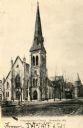
| Date: | 1904 |
|---|---|
| Description: | Exterior view of the Congregational Church. Caption reads: "Congregational Church, Janesville, Wis." |
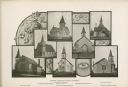
| Date: | 1904 |
|---|---|
| Description: | Composite photograph of views of seven Washburn churches, including Mehtodist Church, Swedish Mission Church, Congregational Church, Norwegian Lutheran Chu... |
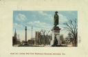
| Date: | 1904 |
|---|---|
| Description: | Looking west from Washington Monument. There is a monument on the right, with the view down the street on the left. A church, two other monuments, and seve... |
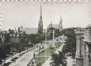
| Date: | 1904 |
|---|---|
| Description: | Elevated view of avenue west of Eight Street. On the left are two churches, a few other buildings, and trees. The road is split with a strip of land that h... |

| Date: | 1904 |
|---|---|
| Description: | West from Ninth Street. Elevated view taken from on top of a building. Churches and trees line the road, which has a strip of land with monuments in the mi... |

| Date: | 1904 |
|---|---|
| Description: | Elevated view of Milwaukee buildings as seen from City Hall, including churches, the Milwaukee Central Police Station and Light Horse Squadron Armory on Br... |

| Date: | 1904 |
|---|---|
| Description: | View of First M.E. Church, partially obscured by trees. The church has two entrances along the frontside, one of which is part of the bell tower. |

| Date: | 1904 |
|---|---|
| Description: | Pathways lead through trees on a lawn to the neo-classical styled White Memorial Library, funded by Mary Flavia White. In front of the library is Birge Fou... |

| Date: | 1904 |
|---|---|
| Description: | This 1904 map of Dane County, Wisconsin, shows postal routes, post office locations, towns, sections, cities and villages, roads, railroads, collection box... |

| Date: | 1904 |
|---|---|
| Description: | This map has three inset maps of Whitefish Bay, Cudahy, and South Milwaukee. This map depicts schools, engine houses, railroads, street railways, city ward... |

| Date: | 1904 |
|---|---|
| Description: | View from below of a small wooden church building standing at the edge of the Montello quarry. In the foreground cables stretch over the quarry hole. The p... |
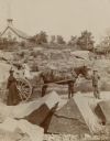
| Date: | 1904 |
|---|---|
| Description: | A boy is standing and holding the bridle of a horse harnessed to an open wagon in the granite quarry. Ethel Richter, standing in the wagon with her sister ... |

| Date: | 1904 |
|---|---|
| Description: | View across a body of water toward several buildings along a shoreline. Caption reads: "Main Street, Necedah, Wis. looking south from the residence of Dr. ... |

| Date: | 1904 |
|---|---|
| Description: | Text on reverse reads: "Multiple View Card, Souvenir of Tomah." The smaller images, which flip when the card on top is pulled, include: Congregational Chur... |
If you didn't find the material you searched for, our Library Reference Staff can help.
Call our reference desk at 608-264-6535 or email us at: