Filter: Categories of Wisconsin Historical Images
Filter: FULL_DATE of 1903
Filter: Subject of roads
Filter: Categories of Wisconsin Historical Images
Filter: FULL_DATE of 1903
Filter: Subject of roads
| Date: | 1903 |
|---|---|
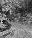
| Description: | Horse-drawn vehicle on Canyon Trail at Mirror Lake. |

| Date: | 1903 |
|---|---|
| Description: | Several buildings in the complex of the F.G. and C.A. Stanley Manufacturing Plant. The largest building is labeled "F.G. and C.A. Stanley." A smaller build... |
| Date: | 1903 |
|---|---|
| Description: | Three rural mail carriers pose with their horses and buggies in front of the Montello Post Office. Postmaster (Dr.) Edward A. Bass stands in the backgroun... |
| Date: | 1903 |
|---|---|
| Description: | A performing dog jumping through a hoop held by a man while a small group of children and adults watch. |

| Date: | 1903 |
|---|---|
| Description: | Composite photograph of one man and two women standing on top of two horses pulling a buggy. The three figures are glued onto the photograph containing the... |

| Date: | 1903 |
|---|---|
| Description: | This 1903 map of Outagamie County, Wisconsin, shows the township and range grid, towns, sections, cities and villages, landownership and acreages, rural ma... |

| Date: | 1903 |
|---|---|
| Description: | This map of Richland County, Wisconsin, shows land ownership and acreages, the township and range grid, sections, cities, towns and post offices, roads, ra... |
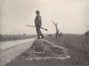
| Date: | 1903 |
|---|---|
| Description: | Statue of John L. Burns, the elderly citizen-hero of the Battle of Gettysburg, who fought with the 7th Wisconsin on July 1, 1863 and was wounded. A veteran... |

| Date: | 1903 |
|---|---|
| Description: | Map of Brown County, Wisconsin, shows the township and range grid, towns, sections, cities, villages and post offices, land owners and acreages, railroads,... |

| Date: | 1903 |
|---|---|
| Description: | Map shows railroads, roads, street car lines, schools, churches, cemeteries, town halls, and railroad stations. Includes inset lists of: Population of Milw... |
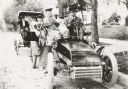
| Date: | 1903 |
|---|---|
| Description: | George S. Parker and family seated in their car, one of the first automobiles in Janesville. Behind them is a couple in another car. |

| Date: | 1903 |
|---|---|
| Description: | Edwin Lally standing on a dirt road next to a fence pushing a wheelbarrow. Farm buildings and haystacks are beyond the fence. |

| Date: | 1903 |
|---|---|
| Description: | View down hill towards two adjoining farmsteads. |

| Date: | 1903 |
|---|---|
| Description: | This map shows lakes, roads, railroads, townships, and land ownership by name. Counties are colored red, blue, or yellow. Lake Michigan is labeled. Also in... |

| Date: | 1903 |
|---|---|
| Description: | This map shows townships and sections, landownership and acreages, roads, railroads, and selected rural buildings. Townships and sections appear in yellow,... |

| Date: | 1903 |
|---|---|
| Description: | This blue line print shows quartzite areas, mines, railroads, and roads. The map covers townships 11-13 north, ranges 4-8 east, in parts of Sauk and Columb... |
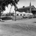
| Date: | 1903 |
|---|---|
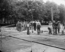
| Description: | View across unpaved road towards construction workers working on the first floor of the Eau Claire Public Library at the intersection of Farwell Street and... |
If you didn't find the material you searched for, our Library Reference Staff can help.
Call our reference desk at 608-264-6535 or email us at: