 Filter: Categories of Wisconsin Historical Images
Filter: FULL_DATE of 1903
Filter: Subject of church buildings
Filter: Categories of Wisconsin Historical Images
Filter: FULL_DATE of 1903
Filter: Subject of church buildings
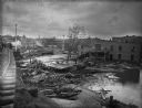
| Date: | 1903 |
|---|---|
| Description: | View from railroads tracks of the wreckage of wooden buildings left behind after a flood. Intact buildings are visible in a skyline in the distance, and pe... |

| Date: | 1903 |
|---|---|
| Description: | This 1903 map of Outagamie County, Wisconsin, shows the township and range grid, towns, sections, cities and villages, landownership and acreages, rural ma... |

| Date: | 1903 |
|---|---|
| Description: | Map of Brown County, Wisconsin, shows the township and range grid, towns, sections, cities, villages and post offices, land owners and acreages, railroads,... |

| Date: | 1903 |
|---|---|
| Description: | Map shows railroads, roads, street car lines, schools, churches, cemeteries, town halls, and railroad stations. Includes inset lists of: Population of Milw... |

| Date: | 1903 |
|---|---|
| Description: | Map shows location of government buildings, schools, churches, parks, and other points of interest. The upper left hand margin features a "Reference" secti... |
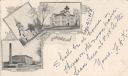
| Date: | 1903 |
|---|---|
| Description: | Postcard with three illustrations — the Cotton Mills, the First M.E. Church, and the High School. |
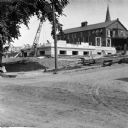
| Date: | 1903 |
|---|---|
| Description: | View across unpaved road towards construction workers working on the first floor of the Eau Claire Public Library at the intersection of Farwell Street and... |
If you didn't find the material you searched for, our Library Reference Staff can help.
Call our reference desk at 608-264-6535 or email us at: