Filter: Categories of Wisconsin Historical Images
Filter: FULL_DATE of 1902
Filter: Subject of rivers
Filter: Categories of Wisconsin Historical Images
Filter: FULL_DATE of 1902
Filter: Subject of rivers
| Date: | 1902 |
|---|---|
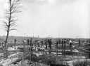
| Description: | The Goar and Stinson log driving crew on the Clam River. |
| Date: | 1902 |
|---|---|
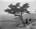
| Description: | Two women and a man pose atop Gibraltar Rock in Richmond Memorial Park, which was dedicated by Jens Jensen and the Wisconsin Friends in 1927 in order to co... |

| Date: | 1902 |
|---|---|
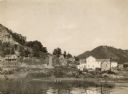
| Description: | River with distant hills behind a town. An island is in the foreground. |

| Date: | 1902 |
|---|---|
| Description: | Two panoramic bird's-eye views of the Paine Lumber Company, including the general plant, sawmill, and lumber yards. Heading at the top says: Home of Wiscon... |

| Date: | 1902 |
|---|---|
| Description: | This map shows the railroads of southern Wisconsin with the routes of the Chicago, Milwaukee, and St. Paul Railway traced in red. The township grid, counti... |

| Date: | 1902 |
|---|---|
| Description: | A map of Milwaukee County, Wisconsin that shows the township and range system, sections, towns, roads, railroads and rail stations, cities and villages, po... |
| Date: | 1902 |
|---|---|
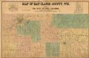
| Description: | This 1902 map of Eau Claire County, Wisconsin, shows the township and range grid, towns, sections, landownership and acreages, roads and railroads, and sel... |

| Date: | 1902 |
|---|---|
| Description: | This 1902 map of Winnebago County, Wisconsin, shows the township and range grid, towns, sections, cities and villages, landownership and acreages, railroad... |

| Date: | 1902 |
|---|---|
| Description: | Map reads: "Milwaukee's Polish Population. Map showing in Red Color the Location and Density of Polish=Speaking Population of the City of Milwaukee, Wis." ... |
| Date: | 1902 |
|---|---|
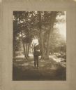
| Description: | Young couple in a park or rural scene near a river. The man, “Mr. Fish” has lifted the young lady, Ida Langenberger, up onto his left shoulder. He is holdi... |
| Date: | 1902 |
|---|---|
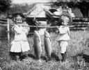
| Description: | Jennie and Edgar Krueger holding a pole between them on their shoulders, with two carp strung up on it. They are standing on a bank next to a river, with a... |
| Date: | 1902 |
|---|---|
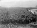
| Description: | Elevated view of a banana plantation located along a river in Costa Rica. |

| Date: | 1902 |
|---|---|
| Description: | This map is a chart of Milwaukee Harbor that displays local streets, bridges, roads, railroads, public buildings, businesses, factories, dry docks, parks, ... |

| Date: | 1902 |
|---|---|
| Description: | This map shows lakes, railroads, and rivers. Also includes an explanation of railroad lines and mileage, information on state institutions, normal schools,... |

| Date: | 1902 |
|---|---|
| Description: | This map shows townships, land parcels, schools, rivers, lakes, creameries, churches, cemeteries, roads, post offices, town halls, saw mills, roads and sto... |

| Date: | 1902 |
|---|---|
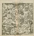
| Description: | A plat map of Lincoln County showing Township 34 North, Range 8 East. |
| Date: | 1902 |
|---|---|
| Description: | A plat map of a portion of Lincoln County, showing Township 35 North, Range 8 East. |
If you didn't find the material you searched for, our Library Reference Staff can help.
Call our reference desk at 608-264-6535 or email us at: