 Filter: Categories of Wisconsin Historical Images
Filter: FULL_DATE of 1902
Filter: County of Milwaukee
Filter: Subject of cities and towns
Filter: Categories of Wisconsin Historical Images
Filter: FULL_DATE of 1902
Filter: County of Milwaukee
Filter: Subject of cities and towns
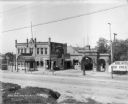
| Date: | 1902 |
|---|---|
| Description: | The Pabst Park beer garden and Park Bar at N. 3rd Street and W. Garfield Avenue (later renamed Garfield and Rose Park). |
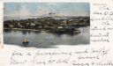
| Date: | 1902 |
|---|---|
| Description: | Elevated view of island with houses and boathouses and boats along the shoreline. Industrial buildings are in the background, and a sailboat is on the wate... |

| Date: | 1902 |
|---|---|
| Description: | A map of Milwaukee County, Wisconsin that shows the township and range system, sections, towns, roads, railroads and rail stations, cities and villages, po... |

| Date: | 1902 |
|---|---|
| Description: | Map reads: "Milwaukee's Polish Population. Map showing in Red Color the Location and Density of Polish=Speaking Population of the City of Milwaukee, Wis." ... |

| Date: | 1902 |
|---|---|
| Description: | Two-wheeled show cart with pair of white show horses in tandem hitch, being driven by one person, probably along Lake Michigan. |
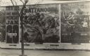
| Date: | 1902 |
|---|---|
| Description: | View from the street of a billboard wall along a sidewalk, advertising Lincoln J. Carter's melodrama play, "Chattanooga." It is playing one night, January ... |

| Date: | 1902 |
|---|---|
| Description: | This map is a chart of Milwaukee Harbor that displays local streets, bridges, roads, railroads, public buildings, businesses, factories, dry docks, parks, ... |
If you didn't find the material you searched for, our Library Reference Staff can help.
Call our reference desk at 608-264-6535 or email us at: