 Filter: Categories of Wisconsin Historical Images
Filter: FULL_DATE of 1900
Filter: Subject of michigan, lake
Filter: Categories of Wisconsin Historical Images
Filter: FULL_DATE of 1900
Filter: Subject of michigan, lake

| Date: | 1900 |
|---|---|
| Description: | W.W. Cargill Company's grain elevator. |
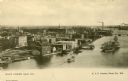
| Date: | 1900 |
|---|---|
| Description: | Elevated view of east Green Bay harbor with cargo ships, W.W. Cagill Co., and other various industries. |
| Date: | 1900 |
|---|---|
| Description: | Elevated view of the Pabst Whitefish Bay Resort. |
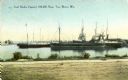
| Date: | 1900 |
|---|---|
| Description: | View from shoreline towards the coal docks on the right, with several ships in the harbor. Caption reads: "Coal Docks, Capacity 100,000 Tons, Two Rivers, W... |
| Date: | 1900 |
|---|---|
| Description: | View across water of a dock and buildings on Lake Michigan. |
| Date: | 1900 |
|---|---|
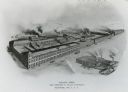
| Description: | Main factory with South Foundry in lower left. Lake Michigan is in the background. Later the Allis-Chalmers Manufacturing Co. |

| Date: | 1900 |
|---|---|
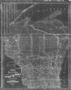
| Description: | A map of Wisconsin, eastern Minnesota and Iowa, northern Iowa, and Michigan’s Upper Peninsula, showing railway lines, with those marked with heavy red line... |

| Date: | 1900 |
|---|---|
| Description: | This map, which shows the state of Wisconsin in 1895, was published as Rand, McNally & Co.'s New business atlas map of Wisconsin. Railroads, counties, citi... |

| Date: | 1900 |
|---|---|
| Description: | A map of Wisconsin, eastern Minnesota and Iowa, and Michigan’s Upper Peninsula, showing the rail lines of the Wisconsin Central Railroad are shown in red, ... |

| Date: | 1900 |
|---|---|
| Description: | Map shows 6 types of zoning districts in Milwaukee township. There is a key identifying four types of land: "AGRICULTURAL," '"A" RESIDENCE.' '"B" RESIDENCE... |

| Date: | 1900 |
|---|---|
| Description: | This map shows city wards, block numbers, parks, cemeteries, roads, railroads, Lake Michigan, and selected buildings. Also included are indexes "Milwaukee ... |

| Date: | 1900 |
|---|---|
| Description: | This map shows railroad routes in red, blue, orange, brown, pink, green, and dotted, as well as lakes, rivers, and communities. The map includes a legend i... |
| Date: | 1900 |
|---|---|
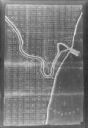
| Description: | This map shows distances along the road, rivers, Indian trails between a shantytown south of Navarino (Green Bay)and Fort Howard. It also shows Lake Winneb... |

| Date: | 1900 |
|---|---|
| Description: | This map shows the boundary lines between ceded and unceded land in compliance with the Treaty of Prairie du Chen of 1829. It also shows roads, rivers, por... |
| Date: | 1900 |
|---|---|
| Description: | This map shows county boundaries, towns, waterways,towns, railroads and proposed railroads, Lake Michigan and Superior. A Portion of Michigan is visible. O... |

| Date: | 1900 |
|---|---|
| Description: | This map shows landownership, railroads, roads, churches, schools, cemeteries, post offices, townships, city wards, Lake Michigan, and rivers. The map incl... |
| Date: | 1900 |
|---|---|
| Description: | This photocopy map shows land parcels, block numbers, streets, the Kewaunee River, and Lake Michigan on the far right side. The original map was created ar... |
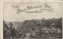
| Date: | 1900 |
|---|---|
| Description: | Text on front reads: "Telephone Lake 136. Pabst Whitefish Bay Summer Resort. H. Konopka, Lessee." Elevated view of Pabst Whitefish Bay Resort on the shores... |

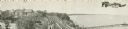
| Date: | 1900 |
|---|---|
| Description: | View of a boat, the Whittaker, with most people sitting in chairs, and a few men standing. In the background is a steep shoreline, with houses along... |
If you didn't find the material you searched for, our Library Reference Staff can help.
Call our reference desk at 608-264-6535 or email us at: