 Filter: Categories of Wisconsin Historical Images
Filter: FULL_DATE of 1900
Filter: Type of Map or Atlas
Filter: Subject of rivers
Filter: Categories of Wisconsin Historical Images
Filter: FULL_DATE of 1900
Filter: Type of Map or Atlas
Filter: Subject of rivers

| Date: | 1900 |
|---|---|
| Description: | A hydrographic map of Lake Monona and the adjacent topography. |

| Date: | 1900 |
|---|---|
| Description: | A map of Wisconsin, eastern Minnesota and Iowa, northern Iowa, and Michigan’s Upper Peninsula, showing railway lines, with those marked with heavy red line... |

| Date: | 1900 |
|---|---|
| Description: | This map, which shows the state of Wisconsin in 1895, was published as Rand, McNally & Co.'s New business atlas map of Wisconsin. Railroads, counties, citi... |

| Date: | 1900 |
|---|---|
| Description: | A map of Wisconsin, eastern Minnesota and Iowa, and Michigan’s Upper Peninsula, showing the rail lines of the Wisconsin Central Railroad are shown in red, ... |

| Date: | 1900 |
|---|---|
| Description: | This map of shows the township grid, counties, cities and villages, lakes, rivers, rail lines and the Menominee Indian Reservation. |

| Date: | 1900 |
|---|---|
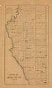
| Description: | A map of La Crosse County, Wisconsin, showing and identifying the townships and section numbers, towns, cities and villages, landowners, rivers, railroads,... |

| Date: | 1900 |
|---|---|
| Description: | A Hydrographic map of Lake Mendota that shows the depths of the lake through contour lines and cross sections of the lake. Also shown in the map are the ad... |

| Date: | 1900 |
|---|---|
| Description: | This map of Sawyer County, Wisconsin, shows the numbered "sub-school-districts of the town of Hayward" school houses, and the Indian reservation. The towns... |
| Date: | 1900 |
|---|---|
| Description: | This map of Adams County, Wisconsin, from E.B. Foote's Plat book of Adams County, Wisconsin, 1900, shows the township and range grid, towns, sections, citi... |

| Date: | 1900 |
|---|---|
| Description: | Shows limits of drainage basin, dams, rapids, roads, and railroads in parts of Iron and Vilas Counties, Wisconsin. From the E.P. Sherry papers relating to ... |

| Date: | 1900 |
|---|---|
| Description: | Map shows 6 types of zoning districts in Milwaukee township. There is a key identifying four types of land: "AGRICULTURAL," '"A" RESIDENCE.' '"B" RESIDENCE... |
| Date: | 1900 |
|---|---|
| Description: | Shows plat of town, local streets, town sections, and Chippewa River. Streets running horizontally begin at the top with "Lake Street" and end with "Water ... |
| Date: | 1900 |
|---|---|
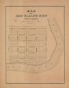
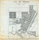
| Description: | This map is ink on tracing paper and shows the city of Spooner. The map shows numbered plats, labeled streets, and the Yellow River. |

| Date: | 1900 |
|---|---|
| Description: | This map of Bangor is ink and pencil on cloth. The map shows roads, railroads, residences, mills, the original plat of Bangor, and the Wisconsin and Wheldo... |

| Date: | 1900 |
|---|---|
| Description: | This map of Green Bay shows plat of the town, lots by number, local streets, the military Fort Howard, part of Fox River and part of Navarino. The map feat... |

| Date: | 1900 |
|---|---|
| Description: | This map of West Navarino shows plat of the town, lots by number, local streets, public square, The Fox River, and Fort Howard. The bottom of the map reads... |

| Date: | 1900 |
|---|---|
| Description: | This map shows city wards, block numbers, parks, cemeteries, roads, railroads, Lake Michigan, and selected buildings. Also included are indexes "Milwaukee ... |

| Date: | 1900 |
|---|---|
| Description: | This photostat map was probably originally created in 1835 and shows in addition to private claims, mills, roads, and trails. Green Bay and the Fox River a... |

| Date: | 1900 |
|---|---|
| Description: | This photocopied map shows private claim owners, buildings, and land use in 1818. Insets show Fort Howard and the caption reads: "A view of the Fox River ... |

| Date: | 1900 |
|---|---|
| Description: | This map shows land owners, railroads, and rivers. |
If you didn't find the material you searched for, our Library Reference Staff can help.
Call our reference desk at 608-264-6535 or email us at: