Filter: Categories of Wisconsin Historical Images
Filter: FULL_DATE of 1899
Filter: Subject of transportation
Filter: Subject of land
Filter: Categories of Wisconsin Historical Images
Filter: FULL_DATE of 1899
Filter: Subject of transportation
Filter: Subject of land
| Date: | 1899 |
|---|---|
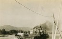
| Description: | The Clyde after being converted to a sternwheel rafter, pushing a tow with a locomotive on board. |
| Date: | 1899 |
|---|---|
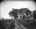
| Description: | Scenic view of a dirt road bounded on either side by split-rail fences. |
| Date: | 1899 |
|---|---|
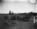
| Description: | View of August, Alex, and Mrs. Alex (Florentina) Krueger working with the binder in a field. |

| Date: | 1899 |
|---|---|
| Description: | Topographical map showing ridges, water courses, boundary lines, and trails and roads near the Stanley McCormick's Riven Rock estate in El Montecito, Santa... |

| Date: | 1899 |
|---|---|
| Description: | Overhead map of the Stanley McCormick's Riven Rock estate in El Montecito, Santa Barbara, California. The map shows the placement of dwellings and fields, ... |

| Date: | 1899 |
|---|---|
| Description: | A map showing the shoreline of a portion of El Montecito, Santa Barbara County, California. The map shows properties along the Pacific Ocean, and may have ... |

| Date: | 1899 |
|---|---|
| Description: | Map of Door County with inset photograph of Sturgeon Bay City. |

| Date: | 1899 |
|---|---|
| Description: | This 1899 map shows the contour depths of Big Cedar Lake in Washington County, Wisconsin, and includes four cross sections of the lake. Roads, railroads, s... |

| Date: | 1899 |
|---|---|
| Description: | This map is a folded insert from the pamphlet "Yesterday and Today : A History." The map features the North-Western Line with labeled railway tracks and st... |
| Date: | 1899 |
|---|---|
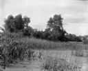
| Description: | View over section of Turvill Marsh towards trees. On the far right in the background are what may be railroad tracks. |

| Date: | 1899 |
|---|---|
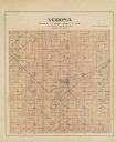
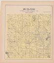
| Description: | A plat map showing Lake Monona, the isthmus in Madison, and the towns of Burke and Blooming Grove. |

| Date: | 1899 |
|---|---|
| Description: | Jeannie Schauers is standing on wooden planks near a pier on the shoreline of Archibald Lake. A rowboat is pulled up on the shoreline on the left. |

| Date: | 1899 |
|---|---|
| Description: | A plat map of Pleasant Springs in Dane County. |

| Date: | 1899 |
|---|---|
| Description: | Three men posing with their bicycles along a picket fence. Caption reads: "On Camp Randall, 1899. Bicycle Team." The name "Sumner" is written in the lower ... |

| Date: | 1899 |
|---|---|
| Description: | A plat map of the township of Christiana. |
If you didn't find the material you searched for, our Library Reference Staff can help.
Call our reference desk at 608-264-6535 or email us at: