 Filter: Categories of Wisconsin Historical Images
Filter: FULL_DATE of 1899
Filter: Subject of streets
Filter: Subject of water
Filter: Categories of Wisconsin Historical Images
Filter: FULL_DATE of 1899
Filter: Subject of streets
Filter: Subject of water

| Date: | 1899 |
|---|---|
| Description: | This map shows parks, block numbers, Lake Michigan, and railroads. Relief is shown by contours. Also included is an explanation that lists how many miles o... |

| Date: | 1899 |
|---|---|
| Description: | A plat map showing Lake Monona, the isthmus in Madison, and the towns of Burke and Blooming Grove. |

| Date: | 1899 |
|---|---|
| Description: | A map of the west part of the city of Madison, including University Heights and the Capitol Square. |

| Date: | 1899 |
|---|---|
| Description: | A map of the east part of the city of Madison, including a portion of the isthmus. |
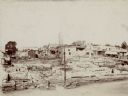
| Date: | 1899 |
|---|---|
| Description: | Elevated view looking west over the open basements of commercial buildings which were destroyed by a recent fire. Main Street is in the foreground. Horse-d... |
If you didn't find the material you searched for, our Library Reference Staff can help.
Call our reference desk at 608-264-6535 or email us at:
