Filter: Categories of Wisconsin Historical Images
Filter: FULL_DATE of 1899
Filter: Subject of human settlements
Filter: Subject of roads
Filter: Categories of Wisconsin Historical Images
Filter: FULL_DATE of 1899
Filter: Subject of human settlements
Filter: Subject of roads
| Date: | 1899 |
|---|---|
| Description: | Farmers lined up with horse-drawn wagons loaded with newly delivered McCormick farm machines on the main street of a rural town. The wagons are adorned wit... |
| Date: | 1899 |
|---|---|
| Description: | Winter scene of two men standing on a snowy street with the Wisconsin State Capitol visible in the background. They are holding snow shovels. |
| Date: | 1899 |
|---|---|
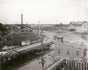
| Description: | Elevated view looking north towards Menomonie, the Knapp, Stout and Company lumber mills. |
| Date: | 1899 |
|---|---|
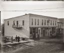
| Description: | Elevated view of group of men standing in front of construction site, near a newly completed building on Main Street, near the intersection of West Montell... |

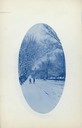
| Date: | 1899 |
|---|---|
| Description: | Front of armory on Broadway Street, which has a single turret and a sign that reads "Light Horse Squadron Armory." Housed the Light Squadron of the Wiscons... |
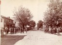
| Date: | 1899 |
|---|---|
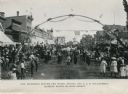
| Description: | View of a marching band parading beneath a decorated arch on Main Street. Onlookers line both sides of the street. American flags are flying over the road ... |
| Date: | 1899 |
|---|---|
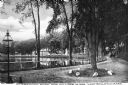
| Description: | A man steers a horse and carriage down a winding country road near Clarendon Pond. Village dwellings are visible across the pond. |

| Date: | 1899 |
|---|---|
| Description: | This 1899 map shows the contour depths of Big Cedar Lake in Washington County, Wisconsin, and includes four cross sections of the lake. Roads, railroads, s... |

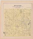
| Date: | 1899 |
|---|---|
| Description: | This 1899 map of Douglas County, Wisconsin, shows the township and range grid, towns, sections, cities, villages and railroad stations, mines, roads, railr... |

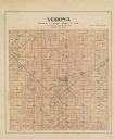
| Date: | 1899 |
|---|---|
| Description: | This 1899 map of Dodge County, Wisconsin, shows the township and range grid, towns, sections, cities and villages, roads, railroads, post offices, cemeteri... |

| Date: | 1899 |
|---|---|
| Description: | This map shows parks, block numbers, Lake Michigan, and railroads. Relief is shown by contours. Also included is an explanation that lists how many miles o... |

| Date: | 1899 |
|---|---|
| Description: | A plat map of Pleasant Springs in Dane County. |

| Date: | 1899 |
|---|---|
| Description: | A plat map of the township of Christiana. |
If you didn't find the material you searched for, our Library Reference Staff can help.
Call our reference desk at 608-264-6535 or email us at: