Filter: Categories of Wisconsin Historical Images
Filter: FULL_DATE of 1899
Filter: Type of Map or Atlas
Filter: Subject of land
Filter: Subject of roads
Filter: Categories of Wisconsin Historical Images
Filter: FULL_DATE of 1899
Filter: Type of Map or Atlas
Filter: Subject of land
Filter: Subject of roads

| Date: | 1899 |
|---|---|
| Description: | Topographical map showing ridges, water courses, boundary lines, and trails and roads near the Stanley McCormick's Riven Rock estate in El Montecito, Santa... |

| Date: | 1899 |
|---|---|
| Description: | Overhead map of the Stanley McCormick's Riven Rock estate in El Montecito, Santa Barbara, California. The map shows the placement of dwellings and fields, ... |

| Date: | 1899 |
|---|---|
| Description: | A map showing the shoreline of a portion of El Montecito, Santa Barbara County, California. The map shows properties along the Pacific Ocean, and may have ... |

| Date: | 1899 |
|---|---|
| Description: | This 1899 map shows the contour depths of Big Cedar Lake in Washington County, Wisconsin, and includes four cross sections of the lake. Roads, railroads, s... |

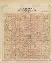
| Date: | 1899 |
|---|---|
| Description: | A plat map of Pleasant Springs in Dane County. |

| Date: | 1899 |
|---|---|
| Description: | A plat map of the township of Christiana. |
If you didn't find the material you searched for, our Library Reference Staff can help.
Call our reference desk at 608-264-6535 or email us at: