 Filter: Categories of Wisconsin Historical Images
Filter: FULL_DATE of 1898
Filter: Subject of streets
Filter: Categories of Wisconsin Historical Images
Filter: FULL_DATE of 1898
Filter: Subject of streets

| Date: | 1898 |
|---|---|
| Description: | University Heights from the Chemistry Building on University Avenue. View includes the University of Wisconsin-Madison football field, on the former site o... |
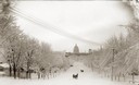
| Date: | 1898 |
|---|---|
| Description: | Winter scene looking down snow-covered Wisconsin Avenue to the third Wisconsin State Capitol. There are two horse-drawn sleighs, each with one passenger, o... |

| Date: | 1898 |
|---|---|
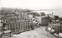
| Description: | Bird's-eye map of Milwaukee with prominent streets and buildings identified. Taken from City Hall Tower. |
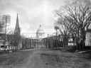
| Date: | 1898 |
|---|---|
| Description: | The third Wisconsin State Capitol as seen from unpaved West Washington Avenue, with the West Wing to the left and the South Wing to the right. The church s... |
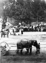
| Date: | 1898 |
|---|---|
| Description: | Elevated view of a man leading a circus elephant on Main Street. On the opposite side of the street is a crowd watching from behind the iron fence on the C... |
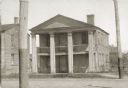
| Date: | 1898 |
|---|---|
| Description: | View of the office building occupied by James Duane Doty during the 1820s when he was additional judge for the U.S. Circuit Court of Michigan Territory. Th... |
| Date: | 1898 |
|---|---|
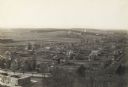
| Description: | Elevated view of the downtown area looking northeast from the courthouse corner. |
| Date: | 1898 |
|---|---|
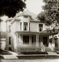
| Description: | The E.T. Billings Residence, Lake Avenue. Mr. Billings was a prominent commercial photographer. |
| Date: | 1898 |
|---|---|
| Description: | View of crowd watching a parade. Elevated view taken from the Van Schaick studio; the same building housed the telephone exchange. |
| Date: | 1898 |
|---|---|
| Description: | Elevated view of Camp Randall and the neighborhoods west of Bascom Hall including University Heights. |
| Date: | 1898 |
|---|---|
| Description: | View across street of dealership or agency building of the McCormick Harvesting Machine Company. Two men stand outside the storefront at two entrances. The... |

| Date: | 1898 |
|---|---|
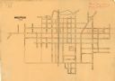
| Description: | Shows landownership, buildings, and railroads. Lake Mendota and Lake Wingra are labelled. |

| Date: | 1898 |
|---|---|
| Description: | This map of Superior shows city wards, bays, docks, and some businesses and points of interest. Relief is shown by hachures. The map probably came from a C... |

| Date: | 1898 |
|---|---|
| Description: | This map of Duluth and Superior show lands that "will be for sale soon" in portions of Douglas County, Wisconsin and Saint Louis County, Minnesota. The map... |
| Date: | 1898 |
|---|---|
| Description: | This is a map of Waupun in 1898 that shows labeled streets, railroads, and the location of the state prison. There are annotations on the map in what appea... |

| Date: | 1898 |
|---|---|
| Description: | Sanborn map of Hurley featuring the Village of Gile. |
| Date: | 1898 |
|---|---|
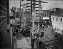
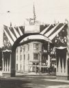
| Description: | Decorated arch erected on State Street as part of the Semi-Centennial celebration of statehood. The arch bears a representation of Commodore Dewey's victor... |

| Date: | 1898 |
|---|---|
| Description: | This map shows blocks, industrial buildings, and railroads in portions of Duluth and Superior, as well as harbor lines, areas improved, and proposed improv... |

| Date: | 1898 |
|---|---|
| Description: | This map shows city wards, block numbers, parks, cemeteries, roads, railroads, Lake Michigan, and selected buildings. Also included are indexes "Milwaukee ... |

| Date: | 1898 |
|---|---|
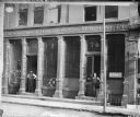
| Description: | View across street towards the buildings on South Pinckney Street. The fence surrounding Capitol Park is on the left. The businesses have signs in their wi... |
If you didn't find the material you searched for, our Library Reference Staff can help.
Call our reference desk at 608-264-6535 or email us at: