 Filter: Categories of Wisconsin Historical Images
Filter: FULL_DATE of 1898
Filter: Subject of schools
Filter: Categories of Wisconsin Historical Images
Filter: FULL_DATE of 1898
Filter: Subject of schools
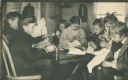
| Date: | 1898 |
|---|---|
| Description: | From a portfolio of collotype prints issued in 1900, a sewing class at Hillside Home School, an early progressive school operated by Ellen and Jane Lloyd J... |

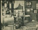
| Date: | 1898 |
|---|---|
| Description: | Ellen Lloyd Jones (also known as Aunt Nell), co-founder of the Hillside Home School, an early progressive school in Wisconsin. |
| Date: | 1898 |
|---|---|
| Description: | Jane Lloyd Jones (also known as Aunt Jen), co-owner of the Hillside Home School, an early progressive school in Wisconsin. |
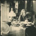
| Date: | 1898 |
|---|---|
| Description: | Interior shot of Aunt Nell's room at Hillside Home School, an early progressive school, operated by Ellen and Jane Lloyd Jones, aunts of Frank Lloyd Wright... |
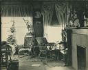
| Date: | 1898 |
|---|---|
| Description: | Interior view of Aunt Jen's room at Hillside Home School, an early progressive school operated by Ellen and Jane Lloyd Jones, aunts of Frank Lloyd Wright. ... |
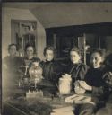
| Date: | 1898 |
|---|---|
| Description: | Students in a chemistry class at Hillside Home School, an early progressive school, operated by Ellen and Jane Lloyd Jones, aunts of Frank Lloyd Wright. |

| Date: | 1898 |
|---|---|
| Description: | A map of Iron County, Wisconsin, shows vacant Wisconsin Central Rail Road lands, settlers houses, land sold by Wisconsin Central R.R., schools, churches, s... |

| Date: | 1898 |
|---|---|
| Description: | This 1898 map shows the township and range system, sections, cities and villages, railroads, vacant land, land sold by the Wisconsin Central Railroad, incl... |

| Date: | 1898 |
|---|---|
| Description: | This 1898 map of Sawyer County, Wisconsin, shows the township and range system, sections, roads, farm houses, camps, school houses, dams, bridges, Indian r... |

| Date: | 1898 |
|---|---|
| Description: | This 1898 map shows the township and range system, sections, cities and villages, railroads, roads, vacant land and land sold by the Wisconsin Central Rail... |

| Date: | 1898 |
|---|---|
| Description: | Map showing the contour depths of the lakes in northwestern Waukesha County, Wisconsin. Roads, railroads, depots, churches, schools, and hotels in the area... |
If you didn't find the material you searched for, our Library Reference Staff can help.
Call our reference desk at 608-264-6535 or email us at: