 Filter: Categories of Wisconsin Historical Images
Filter: FULL_DATE of 1898
Filter: Subject of indian reservations
Filter: Categories of Wisconsin Historical Images
Filter: FULL_DATE of 1898
Filter: Subject of indian reservations
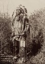
| Date: | 1898 |
|---|---|
| Description: | Full-length portrait of a Sioux man at the Rosebud Agency in full dress, ready for war. |

| Date: | 1898 |
|---|---|
| Description: | A map of Iron County, Wisconsin, shows vacant Wisconsin Central Rail Road lands, settlers houses, land sold by Wisconsin Central R.R., schools, churches, s... |

| Date: | 1898 |
|---|---|
| Description: | This 1898 map of Outagamie County, Wisconsin, shows the township and range grid, towns, sections, cities and villages, the Oneida Reservation, landownershi... |

| Date: | 1898 |
|---|---|
| Description: | This 1898 map of Sawyer County, Wisconsin, shows the township and range system, sections, roads, farm houses, camps, school houses, dams, bridges, Indian r... |

| Date: | 1898 |
|---|---|
| Description: | This 1898 map of Ashland County, Wisconsin, shows the township and range grid, towns, sections, cities and villages, landownership, roads, railroads, swamp... |
If you didn't find the material you searched for, our Library Reference Staff can help.
Call our reference desk at 608-264-6535 or email us at: