 Filter: Categories of Wisconsin Historical Images
Filter: FULL_DATE of 1898
Filter: County of Douglas
Filter: Subject of human settlements
Filter: Categories of Wisconsin Historical Images
Filter: FULL_DATE of 1898
Filter: County of Douglas
Filter: Subject of human settlements
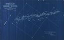
| Date: | 1898 |
|---|---|
| Description: | Topographical map of the Brule River, with white print on blue paper. There is a portion of text on the map that reads "I hereby certify that the above map... |

| Date: | 1898 |
|---|---|
| Description: | This map of Superior shows city wards, bays, docks, and some businesses and points of interest. Relief is shown by hachures. The map probably came from a C... |

| Date: | 1898 |
|---|---|
| Description: | This map of Duluth and Superior show lands that "will be for sale soon" in portions of Douglas County, Wisconsin and Saint Louis County, Minnesota. The map... |

| Date: | 1898 |
|---|---|
| Description: | This map shows blocks, industrial buildings, and railroads in portions of Duluth and Superior, as well as harbor lines, areas improved, and proposed improv... |
If you didn't find the material you searched for, our Library Reference Staff can help.
Call our reference desk at 608-264-6535 or email us at: