 Filter: Categories of Wisconsin Historical Images
Filter: FULL_DATE of 1897
Filter: Year of 1800-1899
Filter: Type of Map or Atlas
Filter: Categories of Wisconsin Historical Images
Filter: FULL_DATE of 1897
Filter: Year of 1800-1899
Filter: Type of Map or Atlas
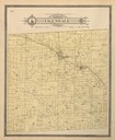
| Date: | 1897 |
|---|---|
| Description: | Plat Map of Glendale Township in Monroe County. |

| Date: | 1897 |
|---|---|
| Description: | A map of Wisconsin showing the self-supporting churches, Home Missionary churches, stations not organized, Sunday schools of C.S.S. Society, Congregational... |

| Date: | 1897 |
|---|---|
| Description: | This 1897 map of Sawyer County, Wisconsin, shows the township and range system, sections, roads, farm houses, camps, school houses, dams, bridges, Indian r... |

| Date: | 1897 |
|---|---|
| Description: | This 1897 map of Winnebago County, Wisconsin, shows the township and range grid, towns, sections, cities and villages, landownership and acreages, rural re... |

| Date: | 1897 |
|---|---|
| Description: | This map shows city wards, block numbers, parks, cemeteries, roads, railroads, Lake Michigan, and selected buildings. Also included are indexes to streets,... |

| Date: | 1897 |
|---|---|
| Description: | Two maps that show cemeteries, schools, engine houses, railroads, street railways, wards, roads, parks, block numbers, and Lake Michigan. One map has wards... |
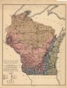
| Date: | 1897 |
|---|---|
| Description: | This map shows the location of quarries throughout the state. Original caption reads, "Geology taken from General Geological Map of Wisconsin by the First ... |
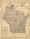
| Date: | 1897 |
|---|---|
| Description: | This map shows the location of quarries throughout the state. Original caption reads, "Geology taken from General Geological Map of Wisconsin by the First ... |
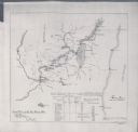
| Date: | 1897 |
|---|---|
| Description: | This map shows the distances along Fox River, as well as adjacent lakes and railroads, between Green Bay and the Wisconsin River. Lake Michigan is on the f... |
If you didn't find the material you searched for, our Library Reference Staff can help.
Call our reference desk at 608-264-6535 or email us at:
