 Filter: Categories of Wisconsin Historical Images
Filter: FULL_DATE of 1897
Filter: Subject of streets
Filter: Categories of Wisconsin Historical Images
Filter: FULL_DATE of 1897
Filter: Subject of streets

| Date: | 1897 |
|---|---|
| Description: | A view from the capitol looking west up State Street toward the University of Wisconsin-Madison with the Holy Redeemer Church, Holy Redeemer School, Red Gy... |
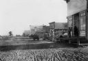
| Date: | 1897 |
|---|---|
| Description: | A dirt street in the business district of Wheeler. |
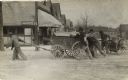
| Date: | 1897 |
|---|---|
| Description: | Men pushing and pulling two carts, one with a barrel, around a street corner. |
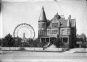
| Date: | 1897 |
|---|---|
| Description: | View of a large, stone residence with the first Ferris Wheel in the distance. |
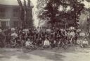
| Date: | 1897 |
|---|---|
| Description: | Portrait of a large group of mostly men in touring clothes posed outdoors with bicycles. |
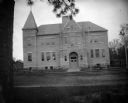
| Date: | 1897 |
|---|---|
| Description: | View across street towards the front of a large brick school building. Identified as the high school built in 1897 in Black River Falls. |

| Date: | 1897 |
|---|---|
| Description: | This map shows city wards, block numbers, parks, cemeteries, roads, railroads, Lake Michigan, and selected buildings. Also included are indexes to streets,... |

| Date: | 1897 |
|---|---|
| Description: | Two maps that show cemeteries, schools, engine houses, railroads, street railways, wards, roads, parks, block numbers, and Lake Michigan. One map has wards... |
If you didn't find the material you searched for, our Library Reference Staff can help.
Call our reference desk at 608-264-6535 or email us at:
