 Filter: Categories of Wisconsin Historical Images
Filter: FULL_DATE of 1897
Filter: Subject of roads
Filter: Categories of Wisconsin Historical Images
Filter: FULL_DATE of 1897
Filter: Subject of roads
| Date: | 1897 |
|---|---|
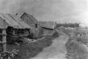
| Description: | Dirt trail passing log shack that was probably the home of Michael and Madeline Cadotte. |

| Date: | 1897 |
|---|---|
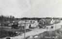
| Description: | View down dirt road, with a few homes on each side of the lane. |
| Date: | 1897 |
|---|---|
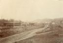
| Description: | Road lined with fences leading into town. Several houses are visible in the distance. A railroad track and electric or telegraph line runs along the left s... |

| Date: | 1897 |
|---|---|
| Description: | Ada Bass, the photographer's wife, leaning against a fence, next to daughter Everetta Bass as a young girl, along a dirt road. The photographer's sister, R... |
| Date: | 1897 |
|---|---|
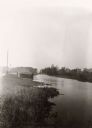
| Description: | View along shoreline of the Yahara River, a small building along the shoreline near a road on the left. The Malt House is in the far background, prior to t... |
| Date: | 1897 |
|---|---|
| Description: | Lumbertown Street (Now Highway 47). There are horse-drawn carts and a car. Sailors burned down Lumbertown in 1897. It was later built up as a resort town.... |
| Date: | 1897 |
|---|---|
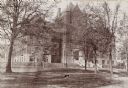
| Description: | View through trees and lawn towards the northwest across Park Street of Science Hall on the University of Wisconsin-Madison campus. |
| Date: | 1897 |
|---|---|
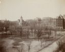
| Description: | Elevated view over Langdon Street of the University of Wisconsin-Madison campus. South Hall, Music Hall, and Science Hall are visible. Bascom Hill and a ce... |

| Date: | 1897 |
|---|---|
| Description: | A map of Wisconsin showing the self-supporting churches, Home Missionary churches, stations not organized, Sunday schools of C.S.S. Society, Congregational... |

| Date: | 1897 |
|---|---|
| Description: | Topographical map of Stanley McCormick's Riven Rock estate in El Montecito, Santa Barbara County, California. The map is identified as a map of a survey co... |

| Date: | 1897 |
|---|---|
| Description: | This 1897 map of Sawyer County, Wisconsin, shows the township and range system, sections, roads, farm houses, camps, school houses, dams, bridges, Indian r... |

| Date: | 1897 |
|---|---|
| Description: | This 1897 map of Winnebago County, Wisconsin, shows the township and range grid, towns, sections, cities and villages, landownership and acreages, rural re... |

| Date: | 1897 |
|---|---|
| Description: | Catalog cover featuring an illustration of a man fixing a bicycle while a woman and two children look on. The woman's outfit sports "leg o' mutton" (or gig... |

| Date: | 1897 |
|---|---|
| Description: | This map shows city wards, block numbers, parks, cemeteries, roads, railroads, Lake Michigan, and selected buildings. Also included are indexes to streets,... |

| Date: | 1897 |
|---|---|
| Description: | Two maps that show cemeteries, schools, engine houses, railroads, street railways, wards, roads, parks, block numbers, and Lake Michigan. One map has wards... |
If you didn't find the material you searched for, our Library Reference Staff can help.
Call our reference desk at 608-264-6535 or email us at: