 Filter: Categories of Wisconsin Historical Images
Filter: FULL_DATE of 1897
Filter: Subject of cities and towns
Filter: Categories of Wisconsin Historical Images
Filter: FULL_DATE of 1897
Filter: Subject of cities and towns
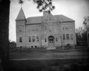
| Date: | 1897 |
|---|---|
| Description: | View across street towards the front of a large brick school building. Identified as the high school built in 1897 in Black River Falls. |
| Date: | 1897 |
|---|---|
| Description: | Robert M. La Follette, Sr., with his arms spread wide, speaking from the back of a wagon. It was in part due to his vigorous speaking style that La Follett... |

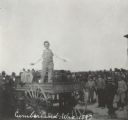
| Date: | 1897 |
|---|---|
| Description: | Robert M. La Follette, Sr., with his fist in the air, speaking from the back of a wagon. He is wearing a hat and a suit without the coat. It was in part du... |

| Date: | 1897 |
|---|---|
| Description: | This map shows city wards, block numbers, parks, cemeteries, roads, railroads, Lake Michigan, and selected buildings. Also included are indexes to streets,... |

| Date: | 1897 |
|---|---|
| Description: | Two maps that show cemeteries, schools, engine houses, railroads, street railways, wards, roads, parks, block numbers, and Lake Michigan. One map has wards... |
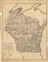
| Date: | 1897 |
|---|---|
| Description: | This map shows the location of quarries throughout the state. Original caption reads, "Geology taken from General Geological Map of Wisconsin by the First ... |
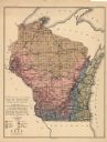
| Date: | 1897 |
|---|---|
| Description: | This map shows the location of quarries throughout the state. Original caption reads, "Geology taken from General Geological Map of Wisconsin by the First ... |
If you didn't find the material you searched for, our Library Reference Staff can help.
Call our reference desk at 608-264-6535 or email us at:
