Filter: Categories of Wisconsin Historical Images
Filter: FULL_DATE of 1896
Filter: Subject of wisconsin river (wis.)
Filter: Categories of Wisconsin Historical Images
Filter: FULL_DATE of 1896
Filter: Subject of wisconsin river (wis.)
| Date: | 1896 |
|---|---|
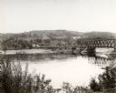
| Description: | Elevated view. Caption on negative sleeve reads: "Black Hawk Battlefield. Wis. Heights. 'Looking it of west across river' [sic] c. 1896. Mrs. Charle... |

| Date: | 1896 |
|---|---|
| Description: | Elevated panoramic view of a section of the Wisconsin Dells and the Wisconsin River visible from the "Sliding Rock." In the lower left hand corner the word... |

| Date: | 1896 |
|---|---|
| Description: | Section 5 of 12, this bicycle road map features Wisconsin bicycle routes in the counties of La Crosse, Monroe, Vernon, Crawford, Richland, Sauk, Juneau, an... |

| Date: | 1896 |
|---|---|
| Description: | A map showing the Wisconsin Central Railroad lines in Wisconsin, northern Illinois, eastern Minnesota, and Michigan’s Upper Peninsula. The area of the map ... |

| Date: | 1896 |
|---|---|
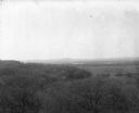
| Description: | View along shoreline of the Wisconsin River, with a sandy beach leading to a stand of trees on the bank on the right. Buildings are along the opposite bank... |
If you didn't find the material you searched for, our Library Reference Staff can help.
Call our reference desk at 608-264-6535 or email us at: