 Filter: Categories of Wisconsin Historical Images
Filter: FULL_DATE of 1896
Filter: Subject of water
Filter: Categories of Wisconsin Historical Images
Filter: FULL_DATE of 1896
Filter: Subject of water

| Date: | 1896 |
|---|---|
| Description: | Shows pipes of various sizes, hydrants with hydrant pressure, valves, wells, projected lines, and suction pipes. Differs from earlier versions by inclusion... |

| Date: | 1896 |
|---|---|
| Description: | This map shows a plat of the town, wards, buildings, the state capitol, local streets, railroads, and parts of Lake Mendota, Lake Monona, and Lake Wingra. ... |

| Date: | 1896 |
|---|---|
| Description: | Catalog cover of Adriance, Platt & Co. features an illustration of a farmer standing in a field holding a scythe and wiping his brow. In the background men... |

| Date: | 1896 |
|---|---|
| Description: | View from sloped lawn of the Lake Mendota shoreline, with the Olin boathouse in the foreground, and the University of Wisconsin-Madison boathouse on the ri... |

| Date: | 1896 |
|---|---|
| Description: | The fish hatchery located south of Madison. Willow trees are along the bank on the left. A field and fence are in the background. |

| Date: | 1896 |
|---|---|
| Description: | This map shows plat of town, local streets, numbered blocks and lots, mill pond, mills, part of the Red Cedar River, and land and property ownership by nam... |

| Date: | 1896 |
|---|---|
| Description: | This map shows streets, wards, railroads, parks, cemeteries, and Lake Michigan. Also included are explanations and an index of points of interest. |

| Date: | 1896 |
|---|---|
| Description: | This map shows railroad routes in red, blue, orange, brown, pink, green, and dotted, as well as lakes, rivers, and communities. The map includes a legend i... |

| Date: | 1896 |
|---|---|
| Description: | This map shows railroads, ordinary roads, good roads, township lines, county lines, county boundaries, towns, lakes, and rivers in the southeastern part ... |

| Date: | 1896 |
|---|---|
| Description: | This map shows the railroad routes of the Wisconsin Central Railroad and its land grant. These are visibly marked in the color red. County boundaries are a... |

| Date: | 1896 |
|---|---|
| Description: | Front cover and interior of banquet menu for Mexican President Porfirio Diaz, to celebrate the construction of a drainage canal between Lake Texcoco and La... |

| Date: | 1896 |
|---|---|
| Description: | This map shows railroads, churches, schools, cemeteries, rivers, lakes, and some rural property owners. |
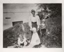
| Date: | 1896 |
|---|---|
| Description: | Caroline Mae Sherwood Turner, wife of Frederick Jackson Turner, with their children Dorothy Kinsley Turner, Jackson Allen Turner, and Mae Sherwood Turner a... |

| Date: | 1896 |
|---|---|
| Description: | View along shoreline of the Wisconsin River, with a sandy beach leading to a stand of trees on the bank on the right. Buildings are along the opposite bank... |
If you didn't find the material you searched for, our Library Reference Staff can help.
Call our reference desk at 608-264-6535 or email us at: