 Filter: Categories of Wisconsin Historical Images
Filter: FULL_DATE of 1896
Filter: Subject of water
Filter: Subject of transportation
Filter: Categories of Wisconsin Historical Images
Filter: FULL_DATE of 1896
Filter: Subject of water
Filter: Subject of transportation

| Date: | 1896 |
|---|---|
| Description: | This map shows railroads, ordinary roads, good roads, township lines, county lines, county boundaries, towns, lakes, and rivers in the southeastern part ... |

| Date: | 1896 |
|---|---|
| Description: | This map shows the railroad routes of the Wisconsin Central Railroad and its land grant. These are visibly marked in the color red. County boundaries are a... |

| Date: | 1896 |
|---|---|
| Description: | Front cover and interior of banquet menu for Mexican President Porfirio Diaz, to celebrate the construction of a drainage canal between Lake Texcoco and La... |

| Date: | 1896 |
|---|---|
| Description: | This map shows railroads, churches, schools, cemeteries, rivers, lakes, and some rural property owners. |
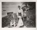
| Date: | 1896 |
|---|---|
| Description: | Caroline Mae Sherwood Turner, wife of Frederick Jackson Turner, with their children Dorothy Kinsley Turner, Jackson Allen Turner, and Mae Sherwood Turner a... |
If you didn't find the material you searched for, our Library Reference Staff can help.
Call our reference desk at 608-264-6535 or email us at: