 Filter: Categories of Wisconsin Historical Images
Filter: FULL_DATE of 1896
Filter: Subject of streams
Filter: Categories of Wisconsin Historical Images
Filter: FULL_DATE of 1896
Filter: Subject of streams
| Date: | 1896 |
|---|---|
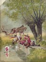
| Description: | Back cover of an advertising catalog for the Milwaukee Harvester Company. The cover features a color chromolithograph illustration of young boys racing hom... |

| Date: | 1896 |
|---|---|
| Description: | A map of Green Lake County, Wisconsin, shows township divisions, villages and post offices, railroads, roads, lakes and streams, schools, and churches. |

| Date: | 1896 |
|---|---|
| Description: | A hand-colored Map of Jefferson County, Wisconsin, shows township and section divisions, towns, villages and post offices, rural residents, railroads, road... |

| Date: | 1896 |
|---|---|
| Description: | A map of Marinette County, Wisconsin that shows the sectioning of townships and other plots, towns, cities and villages, lakes and streams, railroads, and... |

| Date: | 1896 |
|---|---|
| Description: | This 1896 map of Racine and Kenosha counties, Wisconsin, shows the township and range grid, towns, sections, cities, villages and post offices, roads, rail... |

| Date: | 1896 |
|---|---|
| Description: | This 1898 map shows the township and range system, sections, cities and villages, railroads, roads, vacant land and land sold by the Wisconsin Central Rail... |

| Date: | 1896 |
|---|---|
| Description: | This late 19th century map of Walworth County, Wisconsin, shows the township and range grid, towns, sections, villages and post offices, roads, railroads, ... |

| Date: | 1896 |
|---|---|
| Description: | This 1896 map of Washburn County, Wisconsin, shows the township and range grid, sections, schools, wagon roads, cities and villages, settlers, railroads, a... |

| Date: | 1896 |
|---|---|
| Description: | This late 19th-century map of Dodge County, Wisconsin, shows the township and range grid, towns, sections, cities, villages and post offices, some property... |

| Date: | 1896 |
|---|---|
| Description: | This 1896 map of Douglas County, Wisconsin, shows the township and range grid, the towns of Superior, Brule, Gordon, and Nebagamain, sections, cities and v... |
If you didn't find the material you searched for, our Library Reference Staff can help.
Call our reference desk at 608-264-6535 or email us at: