 Filter: Categories of Wisconsin Historical Images
Filter: FULL_DATE of 1896
Filter: Subject of school buildings
Filter: Categories of Wisconsin Historical Images
Filter: FULL_DATE of 1896
Filter: Subject of school buildings

| Date: | 1896 |
|---|---|
| Description: | Bird's-eye view of Washburn, with twenty vignettes around side, water in foreground with docks and lumber corral. Thirty-three locations identified in key ... |
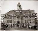
| Date: | 1896 |
|---|---|
| Description: | Group of men posing in front of and on the scaffolding surrounding the Montello School House. The building was completed in 1896. |
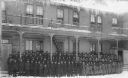
| Date: | 1896 |
|---|---|
| Description: | Indian boys and girls pose for a group portrait outdoors in front of the government school. |

| Date: | 1896 |
|---|---|
| Description: | This 1896 map of Douglas County, Wisconsin, shows the township and range grid, the towns of Superior, Brule, Gordon, and Nebagamain, sections, cities and v... |
If you didn't find the material you searched for, our Library Reference Staff can help.
Call our reference desk at 608-264-6535 or email us at: