 Filter: Categories of Wisconsin Historical Images
Filter: FULL_DATE of 1896
Filter: Subject of land use
Filter: Categories of Wisconsin Historical Images
Filter: FULL_DATE of 1896
Filter: Subject of land use
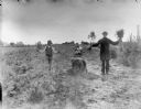
| Date: | 1896 |
|---|---|
| Description: | A boy and a man are holding up small white pine trees, while workers are planting them at Alexander Lake's nursery. In the background are horses and wagons... |
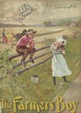
| Date: | 1896 |
|---|---|
| Description: | Cover of an advertising catalog for the Milwaukee Harvester Company, featuring a color chromolithograph illustration of a young boy and girl playing along ... |

| Date: | 1896 |
|---|---|
| Description: | Cover of advertising catalog for the Frost and Wood Company, manufacturers of agricultural implements and harvesting machinery, Smith's Falls, Ontario, Can... |
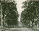
| Date: | 1896 |
|---|---|
| Description: | Jefferson Street south from Doty Street with trees lining the street. |
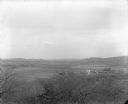
| Date: | 1896 |
|---|---|
| Description: | Elevated view. Caption on negative sleeve reads: "Black Hawk Battlefield. Wis. Heights. 'Looking it of west across river' [sic] c. 1896. Mrs. Charle... |
| Date: | 1896 |
|---|---|
| Description: | Elevated view. Caption on negative sleeve reads: "Black Hawk Battlefield. Wis. Heights. Looking N. of E. up valley towards Catholic Church. Mrs. Charles N.... |
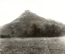
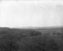
| Date: | 1896 |
|---|---|
| Description: | View of Black Hawk Bluff, site of the Battle of Wisconsin Heights in the Black Hawk War. |

| Date: | 1896 |
|---|---|
| Description: | View of the Old Water Works on East Washington Avenue, as seen from the Capitol Square. |
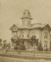
| Date: | 1896 |
|---|---|
| Description: | John Johnston's (1836-1904) first grand home at 1130 Grand Avenue, Milwaukee, Wisconsin. Johnston was a successful Milwaukee banker, who moved to "The Lio... |

| Date: | 1896 |
|---|---|
| Description: | This 1896 map of Racine and Kenosha counties, Wisconsin, shows the township and range grid, towns, sections, cities, villages and post offices, roads, rail... |

| Date: | 1896 |
|---|---|
| Description: | This late 19th century map of Walworth County, Wisconsin, shows the township and range grid, towns, sections, villages and post offices, roads, railroads, ... |
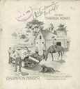
| Date: | 1896 |
|---|---|
| Description: | Front cover of catalog featuring an illustration of a group of men looking at a Champion Mower in the barnyard of a farm. There is a dog in the foreground,... |

| Date: | 1896 |
|---|---|
| Description: | View from sloped lawn of the Lake Mendota shoreline, with the Olin boathouse in the foreground, and the University of Wisconsin-Madison boathouse on the ri... |

| Date: | 1896 |
|---|---|
| Description: | The fish hatchery located south of Madison. Willow trees are along the bank on the left. A field and fence are in the background. |

| Date: | 1896 |
|---|---|
| Description: | This map shows railroads, churches, schools, cemeteries, rivers, lakes, and some rural property owners. |
If you didn't find the material you searched for, our Library Reference Staff can help.
Call our reference desk at 608-264-6535 or email us at: