 Filter: Categories of Wisconsin Historical Images
Filter: FULL_DATE of 1896
Filter: Subject of industries
Filter: Categories of Wisconsin Historical Images
Filter: FULL_DATE of 1896
Filter: Subject of industries

| Date: | 1896 |
|---|---|
| Description: | Loggers posing on narrow-gauge railroad tracks with a railroad velocipede and cant hook near Saddle Mound, a large hill that dominates the local area in Ja... |

| Date: | 1896 |
|---|---|
| Description: | Bird's-eye view of Washburn, with twenty vignettes around side, water in foreground with docks and lumber corral. Thirty-three locations identified in key ... |
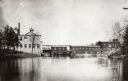
| Date: | 1896 |
|---|---|
| Description: | A view of Nekoosa-Edwards Paper Company mills. Established about 1896 by John Edwards. |

| Date: | 1896 |
|---|---|
| Description: | 40 H.P. experimental tractor. Original caption reads: "40 H.P., Built in 1896." |

| Date: | 1896 |
|---|---|
| Description: | Workers at the Willms cigar factory, Milwaukee, Wisconsin, posing with cigars and cigar boxes. Gustav Willms (c. 1854-1917) sits on the far left with six c... |

| Date: | 1896 |
|---|---|
| Description: | A map of Iron County, Wisconsin, shows vacant Wisconsin Central Rail Road lands, settlers houses, land sold by Wisconsin Central R.R., schools, churches, s... |

| Date: | 1896 |
|---|---|
| Description: | This 1896 map shows the township and range system, sections, cities and villages, railroads, vacant land and land sold by the Wisconsin Central Railroad, s... |

| Date: | 1896 |
|---|---|
| Description: | This 1896 map shows the township and range system, sections, cities and villages, railroads, roads, vacant land and land sold by the Wisconsin Central Rail... |

| Date: | 1896 |
|---|---|
| Description: | This 1898 map shows the township and range system, sections, cities and villages, railroads, roads, vacant land and land sold by the Wisconsin Central Rail... |
If you didn't find the material you searched for, our Library Reference Staff can help.
Call our reference desk at 608-264-6535 or email us at: