 Filter: Categories of Wisconsin Historical Images
Filter: FULL_DATE of 1896
Filter: Subject of human settlements
Filter: Categories of Wisconsin Historical Images
Filter: FULL_DATE of 1896
Filter: Subject of human settlements

| Date: | 1896 |
|---|---|
| Description: | This map shows railroads, churches, schools, cemeteries, rivers, lakes, and some rural property owners. |

| Date: | 1896 |
|---|---|
| Description: | A map of Lincoln, Oneida, and Vilas counties, which also includes part of Iron, Price, and Langlade counties. |

| Date: | 1896 |
|---|---|
| Description: | View along shoreline of the Wisconsin River, with a sandy beach leading to a stand of trees on the bank on the right. Buildings are along the opposite bank... |

| Date: | 1896 |
|---|---|
| Description: | Elevated night view of the eight story Germania Building, which is illuminated with a multitude of individual electric light bulbs outlining the windows an... |
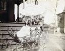
| Date: | 1896 |
|---|---|
| Description: | Jeannette Holt is sitting in her wicker baby carriage which is parked on the sidewalk at the base of the porch stairs at home. An umbrella, attached to thi... |
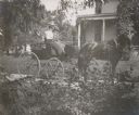
| Date: | 1896 |
|---|---|
| Description: | Holding the whip, Lucy Rumsey Holt is driving the carriage with Minnie May Rumsey sitting beside her. The Evergreens, the Rumsey estate is in the backgroun... |
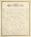
| Date: | 1896 |
|---|---|
| Description: | A plat map of the township of Lima in Pepin County. |

| Date: | 1896 |
|---|---|
| Description: | View down street towards the George Walter Brewing Company. A large group of people are posing on the street with horse-drawn carriages and horse-drawn wag... |
If you didn't find the material you searched for, our Library Reference Staff can help.
Call our reference desk at 608-264-6535 or email us at: