 Filter: Categories of Wisconsin Historical Images
Filter: FULL_DATE of 1896
Filter: Subject of human settlements
Filter: Categories of Wisconsin Historical Images
Filter: FULL_DATE of 1896
Filter: Subject of human settlements

| Date: | 1896 |
|---|---|
| Description: | This 1898 map shows the township and range system, sections, cities and villages, railroads, roads, vacant land and land sold by the Wisconsin Central Rail... |

| Date: | 1896 |
|---|---|
| Description: | This late 19th century map of Walworth County, Wisconsin, shows the township and range grid, towns, sections, villages and post offices, roads, railroads, ... |

| Date: | 1896 |
|---|---|
| Description: | This 1896 map of Washburn County, Wisconsin, shows the township and range grid, sections, schools, wagon roads, cities and villages, settlers, railroads, a... |

| Date: | 1896 |
|---|---|
| Description: | This map of Brown County, Wisconsin, from the late 19th century shows land claims along the Fox River, the township and range grid, towns, sections, cities... |

| Date: | 1896 |
|---|---|
| Description: | This late 19th-century map of Dodge County, Wisconsin, shows the township and range grid, towns, sections, cities, villages and post offices, some property... |

| Date: | 1896 |
|---|---|
| Description: | Map shows landownership and acreages, roads, and townships. |

| Date: | 1896 |
|---|---|
| Description: | This 1896 map of Douglas County, Wisconsin, shows the township and range grid, the towns of Superior, Brule, Gordon, and Nebagamain, sections, cities and v... |

| Date: | 1896 |
|---|---|
| Description: | Map highlighting parks and other points of interest in Milwaukee. |

| Date: | 1896 |
|---|---|
| Description: | Shows pipes of various sizes, hydrants with hydrant pressure, valves, wells, projected lines, and suction pipes. Differs from earlier versions by inclusion... |

| Date: | 1896 |
|---|---|
| Description: | Snapshot of a young man with two young women chatting on Wisconsin Street. The scene is near the Grand Avenue bridge which appears in the background. |

| Date: | 1896 |
|---|---|
| Description: | This map shows a plat of the town, wards, buildings, the state capitol, local streets, railroads, and parts of Lake Mendota, Lake Monona, and Lake Wingra. ... |

| Date: | 1896 |
|---|---|
| Description: | View from sloped lawn of the Lake Mendota shoreline, with the Olin boathouse in the foreground, and the University of Wisconsin-Madison boathouse on the ri... |

| Date: | 1896 |
|---|---|
| Description: | An outdoor portrait of two men with a tandem bicycle. The men stand in a yard near a front walk leading up to a porch. In back of the men is the side of a ... |

| Date: | 1896 |
|---|---|
| Description: | View through open doorway, looking out towards Mrs. Lucius Fairchild and her granddaughter, Frances Bull, standing on a sidewalk. Original caption reads, "... |

| Date: | 1896 |
|---|---|
| Description: | This map shows plat of town, local streets, numbered blocks and lots, mill pond, mills, part of the Red Cedar River, and land and property ownership by nam... |

| Date: | 1896 |
|---|---|
| Description: | This map shows streets, wards, railroads, parks, cemeteries, and Lake Michigan. Also included are explanations and an index of points of interest. |

| Date: | 1896 |
|---|---|
| Description: | This map shows railroad routes in red, blue, orange, brown, pink, green, and dotted, as well as lakes, rivers, and communities. The map includes a legend i... |
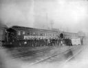
| Date: | 1896 |
|---|---|
| Description: | View across railroad tracks towards a group of glee, banjo and mandolin club members posing in front of a University of Wisconsin banner on the Chicago and... |

| Date: | 1896 |
|---|---|
| Description: | This map shows railroads, ordinary roads, good roads, township lines, county lines, county boundaries, towns, lakes, and rivers in the southeastern part ... |

| Date: | 1896 |
|---|---|
| Description: | This map shows the railroad routes of the Wisconsin Central Railroad and its land grant. These are visibly marked in the color red. County boundaries are a... |
If you didn't find the material you searched for, our Library Reference Staff can help.
Call our reference desk at 608-264-6535 or email us at: