 Filter: Categories of Wisconsin Historical Images
Filter: FULL_DATE of 1896
Filter: Subject of human settlements
Filter: Categories of Wisconsin Historical Images
Filter: FULL_DATE of 1896
Filter: Subject of human settlements

| Date: | 1896 |
|---|---|
| Description: | Interior view of a decorated bay window in a Victorian-era home. The window area was used as a photography back-drop so the shades are drawn and fabric is ... |

| Date: | 1896 |
|---|---|
| Description: | Section 2 of 12, this bicycle road map features Wisconsin bicycle routes in the counties of Marquette, Green Lake, Columbia, Fond Du Lac, Dodge, Washington... |

| Date: | 1896 |
|---|---|
| Description: | Section 3 of 12, this bicycle road map features Wisconsin bicycle routes in the counties of Winnebago, Calumet, Manitowoc, Outagamie, Brown, Kewaunee, and ... |
| Date: | 1896 |
|---|---|
| Description: | Section 4 of 12, this bicycle road map features Wisconsin bicycle routes in the counties of Iowa, Grant, and La Fayette. |

| Date: | 1896 |
|---|---|
| Description: | Section 5 of 12, this bicycle road map features Wisconsin bicycle routes in the counties of La Crosse, Monroe, Vernon, Crawford, Richland, Sauk, Juneau, an... |

| Date: | 1896 |
|---|---|
| Description: | Section 10 of 12, this bicycle road map features Wisconsin bicycle routes in the counties of Polk, Barron, Chippewa, St. Croix, and Dunn. |

| Date: | 1896 |
|---|---|
| Description: | A map of the Chain-O-Lakes in Waupaca, including Indian trails. The path of the Waupaca Electric Railway from the Grand View Hotel to the Wisconsin Central... |
| Date: | 1896 |
|---|---|
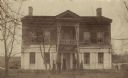
| Description: | The house built by Charles A. Grignon between 1837 and 1839 for Mary Meade, his Pennsylvania bride. Mrs. Grignon and her family are standing in front of th... |
| Date: | 1896 |
|---|---|
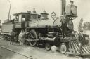
| Description: | Railroad employees pose with locomotive engine no. 925 of the Chicago, Milwaukee & St. Paul Railway. The engine has a long pilot, a large oil headlight, sm... |

| Date: | 1896 |
|---|---|
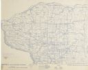
| Description: | This hand-colored map shows counties, county seats, cities, towns, proposed and completed railroads, and U.S. Land Offices. Also included in the map are th... |

| Date: | 1896 |
|---|---|
| Description: | A map showing the Wisconsin Central Railroad lines in Wisconsin, northern Illinois, eastern Minnesota, and Michigan’s Upper Peninsula. The area of the map ... |

| Date: | 1896 |
|---|---|
| Description: | A map of Green Lake County, Wisconsin, shows township divisions, villages and post offices, railroads, roads, lakes and streams, schools, and churches. |

| Date: | 1896 |
|---|---|
| Description: | A map of Iron County, Wisconsin, shows vacant Wisconsin Central Rail Road lands, settlers houses, land sold by Wisconsin Central R.R., schools, churches, s... |

| Date: | 1896 |
|---|---|
| Description: | A hand-colored Map of Jefferson County, Wisconsin, shows township and section divisions, towns, villages and post offices, rural residents, railroads, road... |

| Date: | 1896 |
|---|---|
| Description: | A map of Marinette County, Wisconsin that shows the sectioning of townships and other plots, towns, cities and villages, lakes and streams, railroads, and... |

| Date: | 1896 |
|---|---|
| Description: | A map of Milwaukee County, Wisconsin that shows the township and range system, sections, towns, roads, railroads and rail stations, cities and villages, po... |

| Date: | 1896 |
|---|---|
| Description: | This 1896 map shows the township and range system, sections, cities and villages, railroads, vacant land and land sold by the Wisconsin Central Railroad, s... |

| Date: | 1896 |
|---|---|
| Description: | This 1896 map of Racine and Kenosha counties, Wisconsin, shows the township and range grid, towns, sections, cities, villages and post offices, roads, rail... |

| Date: | 1896 |
|---|---|
| Description: | This 1896 map shows the township and range system, sections, cities and villages, railroads, roads, vacant land and land sold by the Wisconsin Central Rail... |
If you didn't find the material you searched for, our Library Reference Staff can help.
Call our reference desk at 608-264-6535 or email us at:
