 Filter: Categories of Wisconsin Historical Images
Filter: FULL_DATE of 1896
Filter: Subject of church buildings
Filter: Categories of Wisconsin Historical Images
Filter: FULL_DATE of 1896
Filter: Subject of church buildings

| Date: | 1896 |
|---|---|
| Description: | Bird's-eye map of Darlington. Area bordered by Washington and North Streets, upper left hand corner, the fairgrounds, upper right corner, River Street, bot... |

| Date: | 1896 |
|---|---|
| Description: | Bird's-eye view of Washburn, with twenty vignettes around side, water in foreground with docks and lumber corral. Thirty-three locations identified in key ... |
| Date: | 1896 |
|---|---|
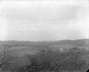
| Description: | Elevated view. Caption on negative sleeve reads: "Black Hawk Battlefield. Wis. Heights. Looking N. of E. up valley towards Catholic Church. Mrs. Charles N.... |
| Date: | 1896 |
|---|---|
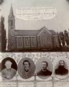
| Description: | Exterior view of St. Norberts Society along with four clergy portraits. |
| Date: | 1896 |
|---|---|
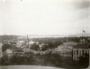
| Description: | View from the Wisconsin State Capitol dome looking west towards Bascom Hill. Mifflin street with City Hall and the Fuller Opera House are in the foreground... |
| Date: | 1896 |
|---|---|
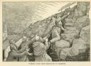
| Description: | Illustration from the Freethinkers Pictorial Text Book of a woman climbing a steep, rocky slope to a sign that reads "Come Up Higher / The Free Thou... |

| Date: | 1896 |
|---|---|
| Description: | A map of Green Lake County, Wisconsin, shows township divisions, villages and post offices, railroads, roads, lakes and streams, schools, and churches. |

| Date: | 1896 |
|---|---|
| Description: | A map of Iron County, Wisconsin, shows vacant Wisconsin Central Rail Road lands, settlers houses, land sold by Wisconsin Central R.R., schools, churches, s... |

| Date: | 1896 |
|---|---|
| Description: | A hand-colored Map of Jefferson County, Wisconsin, shows township and section divisions, towns, villages and post offices, rural residents, railroads, road... |

| Date: | 1896 |
|---|---|
| Description: | A map of Milwaukee County, Wisconsin that shows the township and range system, sections, towns, roads, railroads and rail stations, cities and villages, po... |

| Date: | 1896 |
|---|---|
| Description: | This 1896 map shows the township and range system, sections, cities and villages, railroads, vacant land and land sold by the Wisconsin Central Railroad, s... |

| Date: | 1896 |
|---|---|
| Description: | This 1896 map of Racine and Kenosha counties, Wisconsin, shows the township and range grid, towns, sections, cities, villages and post offices, roads, rail... |

| Date: | 1896 |
|---|---|
| Description: | This 1896 map shows the township and range system, sections, cities and villages, railroads, roads, vacant land and land sold by the Wisconsin Central Rail... |

| Date: | 1896 |
|---|---|
| Description: | This map of Brown County, Wisconsin, from the late 19th century shows land claims along the Fox River, the township and range grid, towns, sections, cities... |

| Date: | 1896 |
|---|---|
| Description: | This late 19th-century map of Dodge County, Wisconsin, shows the township and range grid, towns, sections, cities, villages and post offices, some property... |
If you didn't find the material you searched for, our Library Reference Staff can help.
Call our reference desk at 608-264-6535 or email us at: