 Filter: Categories of Wisconsin Historical Images
Filter: FULL_DATE of 1895
Filter: Year of 1800-1899
Filter: Type of Map or Atlas
Filter: Categories of Wisconsin Historical Images
Filter: FULL_DATE of 1895
Filter: Year of 1800-1899
Filter: Type of Map or Atlas
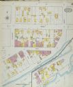
| Date: | 1895 |
|---|---|
| Description: | Sanborn-Perris fire insurance maps for city of Menasha. |
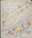
| Date: | 1895 |
|---|---|
| Description: | Sanborn-Perris fire insurance maps for city of Menasha. |

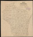
| Date: | 1895 |
|---|---|
| Description: | A map of Wisconsin that shows the counties, cities, towns, rivers, and lakes of the state, the eastern most portions of Minnesota, Iowa, northern Illinois,... |

| Date: | 1895 |
|---|---|
| Description: | This late 19th century map of northern Wisconsin and a portion of Michigan's Upper Peninsula shows the township and range grid, the (Lac du) Flambeau India... |
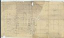
| Date: | 1895 |
|---|---|
| Description: | This map is pencil and red ink on tracing paper and shows sold lots and some names of landowners. Handwritten annotations read: "SE 1/4 of NW 1/4 of sec. 2... |

| Date: | 1895 |
|---|---|
| Description: | Map showing the continents of the world with the Americas at the center. From left to right land masses names are: "Siberia, Chinese Empire, Australia, Nor... |
| Date: | 1895 |
|---|---|
| Description: | This map shows the populations for each county in accordance with the census of 1895. The original captions read, " Total population-1,937,915. Diagram sho... |
If you didn't find the material you searched for, our Library Reference Staff can help.
Call our reference desk at 608-264-6535 or email us at:

