Filter: Categories of Wisconsin Historical Images
Filter: FULL_DATE of 1894
Filter: Subject of streets
Filter: Categories of Wisconsin Historical Images
Filter: FULL_DATE of 1894
Filter: Subject of streets
| Date: | 1894 |
|---|---|
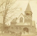
| Description: | View of the German Methodist Church with George Bowers, a milkman, standing in the foreground. |

| Date: | 1894 |
|---|---|
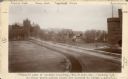
| Description: | Caption reads: "Madison, Wis. About 1894. Pinckney Street looking from 309 N. Pinckney." This was the home of Frederick King Conover. |

| Date: | 1894 |
|---|---|
| Description: | Elevated view looking down at wagons and crowd gathering for McCormick Day parade. "McCormick Day" was a promotional device sponsored by the McCormick Harv... |

| Date: | 1894 |
|---|---|
| Description: | This map shows lot and block numbers, railroads, street car tracks, sewers, water mains, gas mains, paved streets, land owned by the Land & River Improveme... |
| Date: | 1894 |
|---|---|
| Description: | Caption from photograph: "Proposed site of library building. Wis[consin] Histor[ical] Soc[iety].--looking N.W. Building would occupy place now covered by t... |

| Date: | 1894 |
|---|---|
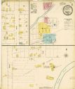
| Description: | Sanborn map of Milwaukee, with the Milwaukee River on the left, and Water Street in the center. There are two iron draw bridges over the river. |

| Date: | 1894 |
|---|---|
| Description: | This map shows railroads, street railways, roads, wards, block numbers, parks, Lake Michigan, and one mile concentric circles indicating distance from the ... |

| Date: | 1894 |
|---|---|
| Description: | This map shows sewers, intercepting sewers, manholes, block numbers, streets, railroads, parks, cemeteries, and Lake Michigan. The right margin reads: "Tot... |

| Date: | 1894 |
|---|---|
| Description: | This map shows railroads, street railways, ward lines, land parcels, streets, schools and public buildings. Ward lines are highlighted in red. Lake Michiga... |
If you didn't find the material you searched for, our Library Reference Staff can help.
Call our reference desk at 608-264-6535 or email us at: