Filter: Categories of Wisconsin Historical Images
Filter: FULL_DATE of 1894
Filter: Type of Map or Atlas
Filter: Subject of land
Filter: Categories of Wisconsin Historical Images
Filter: FULL_DATE of 1894
Filter: Type of Map or Atlas
Filter: Subject of land

| Date: | 1894 |
|---|---|
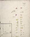
| Description: | Sanborn map of a portion of Milwaukee, including St. Clair and Bishop and Potter Avenues. There is an inset for the South Side Wood Working Co. |

| Date: | 1894 |
|---|---|
| Description: | Sanborn Map of the Illinois Steel Co. Bay View Works in Milwaukee. |

| Date: | 1894 |
|---|---|
| Description: | A detail of a Wisconsin map showing Sawyer, Chippewa and Price counties. |

| Date: | 1894 |
|---|---|
| Description: | A map of the state of Wisconsin sectioned by county. Scale: eight miles to the inch. |

| Date: | 1894 |
|---|---|
| Description: | This map shows lot and block numbers, railroads, street car tracks, sewers, water mains, gas mains, paved streets, land owned by the Land & River Improveme... |
If you didn't find the material you searched for, our Library Reference Staff can help.
Call our reference desk at 608-264-6535 or email us at: