 Filter: Categories of Wisconsin Historical Images
Filter: FULL_DATE of 1893
Filter: Subject of recreation areas
Filter: Categories of Wisconsin Historical Images
Filter: FULL_DATE of 1893
Filter: Subject of recreation areas
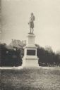
| Date: | 1893 |
|---|---|
| Description: | Side view of monument with plaque. Behind the statue is a road, trees, and the top of a building. A fire hydrant and a small group of people are on the ri... |
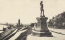
| Date: | 1893 |
|---|---|
| Description: | Statue of Leif Ericson is to the right of center in the foreground, with the figure facing the city. On the left is a hill with paths, a train station, ra... |

| Date: | 1893 |
|---|---|
| Description: | This map of La Crosse shows city ward boundaries in red, streets, railroads, cemeteries, Grand station crossing, the road to French Island, depots, Lake Pa... |

| Date: | 1893 |
|---|---|
| Description: | This map shows wards, railroads, street cars, streets, lot and block numbers, landownership, parks, hospitals, the Sheboygan River, and Lake Michigan. Ward... |

| Date: | 1893 |
|---|---|
| Description: | This map covers west to Wauwatosa, north to North Milwaukee, and south to South Milwaukee and shows street railways, city limits, parks, roads, railroads, ... |

| Date: | 1893 |
|---|---|
| Description: | This map shows city wards, block numbers, parks, cemeteries, roads, railroads, selected buildings, and Lake Michigan. Also included are indexes to streets,... |
If you didn't find the material you searched for, our Library Reference Staff can help.
Call our reference desk at 608-264-6535 or email us at: