 Filter: Categories of Wisconsin Historical Images
Filter: FULL_DATE of 1893
Filter: Creator Name of Pauli, C. J.
Filter: Year of 1800-1899
Filter: Categories of Wisconsin Historical Images
Filter: FULL_DATE of 1893
Filter: Creator Name of Pauli, C. J.
Filter: Year of 1800-1899

| Date: | 1893 |
|---|---|
| Description: | This photocopy of a bird’s-eye-view map shows illustrated houses and various buildings. Streets and the Rock River are labeled. An index to points of inter... |

| Date: | 1893 |
|---|---|
| Description: | Bird's-eye map of Green Bay and Fort Howard, looking south. Ninety-four locations identified below image; extends to Grignon Street at top left corner, Wi... |

| Date: | 1893 |
|---|---|
| Description: | Bird's-eye map of Jefferson, looking north. Crayfish River at left and center, Rock River from upper center to bottom center, joins at left of center; thir... |
| Date: | 1893 |
|---|---|
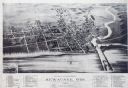
| Description: | Bird's-eye map of Kewaunee, with inset of The Kewaunee and Frankfort Car Ferry Line. |

| Date: | 1893 |
|---|---|
| Description: | Bird's-eye map of Sturgeon Bay, looking Northeast. Area bordered by Church Street in top left corner, leather & Smith Bridge in bottom left corner, Lawrenc... |

| Date: | 1893 |
|---|---|
| Description: | Bird’s-eye view of Depere looking North. Includes illustrations and an index to points of interest. |
If you didn't find the material you searched for, our Library Reference Staff can help.
Call our reference desk at 608-264-6535 or email us at:
