 Filter: Categories of Wisconsin Historical Images
Filter: FULL_DATE of 1892
Filter: Subject of superior, lake
Filter: Categories of Wisconsin Historical Images
Filter: FULL_DATE of 1892
Filter: Subject of superior, lake
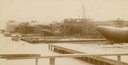
| Date: | 1892 |
|---|---|
| Description: | Text at bottom reads: Ship Yards — McDougall Whaleback. West Superior, Wis." Whaleback steamer in the shipyards of the American Steel Barge Company. |
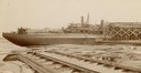
| Date: | 1892 |
|---|---|
| Description: | Text at bottom reads: Ship Yards — McDougall Whaleback. West Superior, Wis." Captain Alex McDougall's whaleback steamer in the shipyard of the American Ste... |

| Date: | 1892 |
|---|---|
| Description: | A cloth mounted, hand-colored map of Wisconsin showing the rail routes, counties, cities, towns, rivers and lakes in the state. The map also shows eastern ... |

| Date: | 1892 |
|---|---|
| Description: | This map of Bayfield shows roads, lots, and township boundaries. The map was originally published on one sheet but is now separated into front and back. On... |

| Date: | 1892 |
|---|---|
| Description: | This map shows the St. Louis Bay, Lake Superior, railroads, railroad yards, main roads, additions, and selected buildings in Superior and parts of the Town... |
| Date: | 1892 |
|---|---|
| Description: | This map shows railroad routes. County boundaries, towns, rivers, lakes, Lake Michigan and Superior are also labeled. The upper margin includes a color leg... |

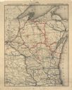
| Date: | 1892 |
|---|---|
| Description: | This map shows the entire state with railroad routes shown in red, blue, orange, green, brown, pink, green, and black. Also labeled are counties, cities, t... |
If you didn't find the material you searched for, our Library Reference Staff can help.
Call our reference desk at 608-264-6535 or email us at: