 Filter: Categories of Wisconsin Historical Images
Filter: FULL_DATE of 1892
Filter: Subject of railroad stations
Filter: Categories of Wisconsin Historical Images
Filter: FULL_DATE of 1892
Filter: Subject of railroad stations

| Date: | 1892 |
|---|---|
| Description: | This map shows schools, engine houses, railroads, street railways, wards, parks, cemeteries, block numbers, a street index, explanations, and general refer... |

| Date: | 1892 |
|---|---|
| Description: | A Sanborn map of St. Louis, which is six miles southwest of South Superior. |
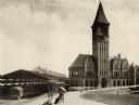
| Date: | 1892 |
|---|---|
| Description: | View of the Chicago & Northwestern Railroad station in Milwaukee. A couple is sitting on a bench under an umbrella in the foreground. The baggage car of a ... |
If you didn't find the material you searched for, our Library Reference Staff can help.
Call our reference desk at 608-264-6535 or email us at: