 Filter: Categories of Wisconsin Historical Images
Filter: FULL_DATE of 1892
Filter: Subject of land
Filter: Categories of Wisconsin Historical Images
Filter: FULL_DATE of 1892
Filter: Subject of land

| Date: | 1892 |
|---|---|
| Description: | Bird's-eye map of Princeton, with an inset of the Residence of F.T. Yahr. Fox River loops to left of center, with one bridge; thirty-six businesses, reside... |

| Date: | 1892 |
|---|---|
| Description: | Bird's-eye view of Chicago, with ships in the Lake Michigan harbor. |
| Date: | 1892 |
|---|---|
| Description: | Exterior of Hillside Home School, an early progressive school operated by Ellen and Jane Lloyd Jones, aunts of Frank Lloyd Wright. |

| Date: | 1892 |
|---|---|
| Description: | Bird's-eye view of the Columbian Exposition pavilions from the vantage point of Lake Michigan. Included is an inset of the Union Passenger Station (now Uni... |
| Date: | 1892 |
|---|---|
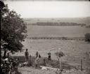
| Description: | A view of the Sauk Prairie looking south. From the left are the photographer's brother, Frank Bass; Mrs. Edward (Ada Burlingame) Bass and her daughter, Eve... |

| Date: | 1892 |
|---|---|
| Description: | Topographical map of Madison and surrounding communities which include Lake Mendota, Lake Monona, Lake Waubesa and Lake Kegonsa. The red dots on the map sh... |

| Date: | 1892 |
|---|---|
| Description: | A cloth mounted, hand-colored map of Wisconsin showing the rail routes, counties, cities, towns, rivers and lakes in the state. The map also shows eastern ... |

| Date: | 1892 |
|---|---|
| Description: | This 1892 map of Douglas County, Wisconsin, shows the township and range grid, towns, sections, cities and villages, roads, railroads, trails, lakes and st... |

| Date: | 1892 |
|---|---|
| Description: | This map shows the dams and locks of the Fox River between Neenah, in Winnebago County, Wisconsin, and Kaukauna, in Outagamie County. The cities and villag... |

| Date: | 1892 |
|---|---|
| Description: | 1 map on 4 sheets : col., mounted on cloth ; Shows landownership, roads and railroads, townships, and selected buildings. Includes "Professional directory... |

| Date: | 1892 |
|---|---|
| Description: | Map shows farms, schools, saw mills, townships, railroads, and roads. Counties are labelled and are outlined in yellow and pink. On the upper right and le... |
| Date: | 1892 |
|---|---|
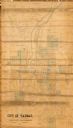
| Description: | This map shows lot and block numbers and dimensions, some landownership, wards, railroads, streets, and mills. The map includes 5 plat additions that have ... |
| Date: | 1892 |
|---|---|
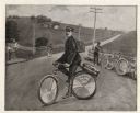
| Description: | Portrait of Frank Lenz on his safety bicycle which he rode on a round-the-world tour. He is posed on a country road lined with fences and telegraph or tele... |

| Date: | 1892 |
|---|---|
| Description: | Elevated view upriver towards a railroad bridge crossing the river. Rocks are in the foreground in the middle of the river. Identified as the bridge across... |

| Date: | 1892 |
|---|---|
| Description: | Elevated view upriver towards a bridge and dam. Two people are walking among the rocks on the lower right. Identified as the railroad bridge across the Bla... |

| Date: | 1892 |
|---|---|
| Description: | This map shows rivers, lakes, railroad lines, roads, and communities in addition to geological data. The map includes cross-sections in the bottom margin a... |
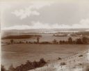
| Date: | 1892 |
|---|---|
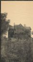
| Description: | An elevated view of a gently rolling landscape with cows grazing in the middle distance. At right is a farmhouse and outbuildings. Young trees have been pl... |
If you didn't find the material you searched for, our Library Reference Staff can help.
Call our reference desk at 608-264-6535 or email us at: