 Filter: Categories of Wisconsin Historical Images
Filter: FULL_DATE of 1892
Filter: Type of Map or Atlas
Filter: Categories of Wisconsin Historical Images
Filter: FULL_DATE of 1892
Filter: Type of Map or Atlas
| Date: | 1892 |
|---|---|
| Description: | This map shows railroad routes. County boundaries, towns, rivers, lakes, Lake Michigan and Superior are also labeled. The upper margin includes a color leg... |

| Date: | 1892 |
|---|---|
| Description: | This map shows rivers, lakes, railroad lines, roads, and communities in addition to geological data. The map includes cross-sections in the bottom margin a... |

| Date: | 1892 |
|---|---|
| Description: | This map shows pipes of various sizes, hydrants with hydrant pressure, valves, wells, and projected lines. Includes labels for roadways, blocks, wards, par... |

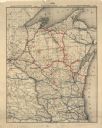
| Date: | 1892 |
|---|---|
| Description: | This map shows the entire state with railroad routes shown in red, blue, orange, green, brown, pink, green, and black. Also labeled are counties, cities, t... |

| Date: | 1892 |
|---|---|
| Description: | A Sanborn map of St. Louis, which is six miles southwest of South Superior. |

| Date: | 1892 |
|---|---|
| Description: | A Sanborn fire insurance map of Sauk City which was drawn up in 1892. |
If you didn't find the material you searched for, our Library Reference Staff can help.
Call our reference desk at 608-264-6535 or email us at: