 Filter: Categories of Wisconsin Historical Images
Filter: FULL_DATE of 1890
Filter: Subject of water
Filter: Categories of Wisconsin Historical Images
Filter: FULL_DATE of 1890
Filter: Subject of water
| Date: | 1890 |
|---|---|
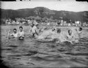
| Description: | View across water towards men and boys swimming and splashing in the Mississippi River. Alma is in the background on the far shoreline. |
| Date: | 1890 |
|---|---|
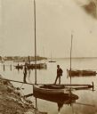
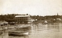
| Description: | Two men pose on a boat docked at the Askew Steamboat Landing on Lake Monona off South Carroll Street. The old Governor Harvey residence is in the backgroun... |
| Date: | 1890 |
|---|---|
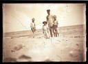
| Description: | A man and three boys in swimming suits at the beach. Presumably, Lake Michigan. |

| Date: | 1890 |
|---|---|
| Description: | Bird's-eye map of Ashland, viewed from Lake Superior, with insets of Prentice Park and Fishery. Population 16,000. Increase in Ten Years, 11,000. |

| Date: | 1890 |
|---|---|
| Description: | Portion of the plat map of the north part of Caledonia in Columbia County, including explanations. |

| Date: | 1890 |
|---|---|
| Description: | Plat map of the south part of Caledonia in Columbia County. |
| Date: | 1890 |
|---|---|
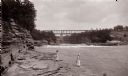
| Description: | Below Kilbourn log dam, 1890s. Two girls are standing on the edge of the river. There is a bridge in the background. |
| Date: | 1890 |
|---|---|
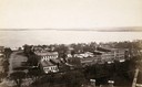
| Description: | Looking south from the capitol dome of the Wisconsin State Capitol, the view is of West Main Street bound by South Hamilton Street and Monona Avenue (now M... |

| Date: | 1890 |
|---|---|
| Description: | Bird's-eye map of Beloit with insets of Williams Engine Works, Eclipse Wind Engine Co., and John Foster & Co. Turtle Creek is in the lower section, and the... |

| Date: | 1890 |
|---|---|
| Description: | Bird's-eye view of Superior, Wisconsin. |

| Date: | 1890 |
|---|---|
| Description: | Bird's-eye map of West Superior and Superior, with insets of Wright Farm and First Building in Superior. |

| Date: | 1890 |
|---|---|
| Description: | Colored bird's-eye map of Oconomowoc and the Lake Region, Waukesha County. Looking North from Government Hill. Location key below image identifies 24 Hotel... |
| Date: | 1890 |
|---|---|
| Description: | Old Mission Inn and boats on shoreline of Lake Superior on Madeline Island. The Old Mission Inn had numerous modifications over the years. It was razed in... |
| Date: | 1890 |
|---|---|
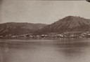
| Description: | Mississippi River, with Alma in the distance, a typical river town which flourished in the 1850s. |
| Date: | 1890 |
|---|---|
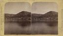
| Description: | Stereograph of Alma from the Mississippi River. Text on front reads: "Wisconsin Scenery". |
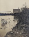
| Date: | 1890 |
|---|---|
| Description: | Trempealeau River and its banks, with a building and bridge in the background. Caption reads: "Trempealeau River Scene, Blair, Wis." |

| Date: | 1890 |
|---|---|
| Description: | Field and trees and water are in the foreground. On the far shoreline are buildings in the town. |

| Date: | 1890 |
|---|---|
| Description: | Stereograph of the upper Mississippi River. The text on the photograph reads: "From Whitney's Gallery, St. Paul, Minn." |
If you didn't find the material you searched for, our Library Reference Staff can help.
Call our reference desk at 608-264-6535 or email us at:

