 Filter: Categories of Wisconsin Historical Images
Filter: FULL_DATE of 1890
Filter: Subject of transportation
Filter: Categories of Wisconsin Historical Images
Filter: FULL_DATE of 1890
Filter: Subject of transportation
| Date: | 1890 |
|---|---|
| Description: | Map of Merrill Estate property for sale and sold. Map reads: "Merrill Estate property (colored) lots marked X are sold for terms & prices inquire of S.H. C... |

| Date: | 1890 |
|---|---|
| Description: | Shows plat of town, local streets, steam boat landings, and Chippewa River. Public square and Muskoo Island hand-colored. Map reads: "Full Lots are 125x66 ... |
| Date: | 1890 |
|---|---|
| Description: | The map shows roads and railroads, houses, schools, town halls, and other points of interest in parts of Shawano, Oconto, and Brown counties. The lower lef... |

| Date: | 1890 |
|---|---|
| Description: | Map shows St. Croix, Wisconsin and a small portion of Taylor's Falls, Minnesota. Map reads: "The Lands shaded show the Mill & Riparian Reservation & unplat... |
| Date: | 1890 |
|---|---|
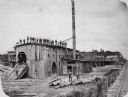
| Description: | Men pose on top of and in front of the Spaulding, Van Hoosier & Company Sawmill. |
| Date: | 1890 |
|---|---|
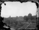
| Description: | Elevated view along Langdon Street towards Science Hall on Bascom Hill at the University of Wisconsin-Madison. On the opposite side of Bascom Hill is Music... |

| Date: | 1890 |
|---|---|
| Description: | This map of Superior shows labeled streets, railroads, docks, city wards, and the state line. Relief is shown by hachures. Below the title reads: "Bedford ... |

| Date: | 1890 |
|---|---|
| Description: | This map of Superior shows city wards, bays, docks, some businesses and points of interest. Relief is shown by hachures. The back of the map features a typ... |

| Date: | 1890 |
|---|---|
| Description: | This is a plat map of "Wauzeeka" drawn in pencil. The map shows numbered lots, labeled streets, the Kickapoo River, and railroads. The map reads: "Laid out... |
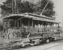
| Date: | 1890 |
|---|---|
| Description: | Special open streetcar called the MARGUERITE, with elaborate lighting, decorations, movable chairs and other features. |

| Date: | 1890 |
|---|---|
| Description: | Group of tourists and crew members on the bow deck of the DELL QUEEN, an excursion boat that operated on the Wisconsin River at Wisconsin Dells. |

| Date: | 1890 |
|---|---|
| Description: | This map is a plat map and shows government buildings, churches, Klein’s Park, and the government dam in Kaukauna. The map includes text about Kaukauna wit... |
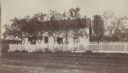
| Date: | 1890 |
|---|---|
| Description: | View across road towards the house where General Reynolds' body was taken after he was killed on the first day of the Battle of Gettysburg. |

| Date: | 1890 |
|---|---|
| Description: | This map shows lot and block numbers, established dock lines, docks, slips, railroads, streets, selected industrial buildings, sites for manufactories, and... |
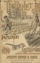
| Date: | 1890 |
|---|---|
| Description: | Cover of the Planet Jr. catalog. Features an illustration of a man and young girl (about 5 or 6 years old) in a garden pushing a Planet Jr. Garden Drill to... |

| Date: | 1890 |
|---|---|
| Description: | View down unpaved street, which has numerous horse-drawn vehicles parked along the curbs. People are on the street and sidewalk, with a larger group and a ... |

| Date: | 1890 |
|---|---|
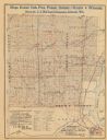
| Description: | This map features township outlines, railroads, roads, post offices, and landownership for La Crosse County. Various communities appear in yellow, green, a... |

| Date: | 1890 |
|---|---|
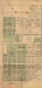
| Description: | This map shows lot and block numbers and dimensions, landownership, city wards, buildings, streets, railroads, parks, cemeteries, churches, schools, and in... |

| Date: | 1890 |
|---|---|
| Description: | Five teenagers ride "High Wheeler or Penny-Farthing" bicycles down the street. Grand Avenue Congregational Church is in the background. Mature trees are on... |
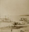
| Date: | 1890 |
|---|---|
| Description: | Elevated view from shoreline of two side wheeled steamboats, the "Lucius Newberry," left, and the "Lady of the Lake," docked at Geneva Lake. Other smaller ... |
If you didn't find the material you searched for, our Library Reference Staff can help.
Call our reference desk at 608-264-6535 or email us at: