 Filter: Categories of Wisconsin Historical Images
Filter: FULL_DATE of 1890
Filter: Subject of transportation
Filter: Categories of Wisconsin Historical Images
Filter: FULL_DATE of 1890
Filter: Subject of transportation

| Date: | 1890 |
|---|---|
| Description: | Men and women ascend a staircase toward a shoe store as horses and carriages travel along the street below. The sign on the store reads, "Victor LaFrance R... |
| Date: | 1890 |
|---|---|
| Description: | Exterior view from across road of men gathered outside a store and saloon. Most of the men hold a glass of beer as though toasting. Two teams of horses are... |
| Date: | 1890 |
|---|---|
| Description: | "For prices, terms and all particulars regarding these lands, apply to Charles E. Simmons, Land Commissioner, Chicago & North-Western Railway, Chicago, Ill... |

| Date: | 1890 |
|---|---|
| Description: | The "J.C. Ames," a Lake Michigan car ferry, probably in the South Chicago harbor. There is a railroad bridge visible in the background. |

| Date: | 1890 |
|---|---|
| Description: | Elevated view of town, probably looking south from the Van Schaick residence. |

| Date: | 1890 |
|---|---|
| Description: | A map of Wisconsin, eastern Wisconsin and Iowa, northern Illinois, and the Upper Peninsula of Michigan. The counties, cities and villages, and rail lines i... |
| Date: | 1890 |
|---|---|
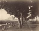
| Description: | View down road lined with trees in Egypt. A group of Egyptians are standing and sitting between the trees and the river, and travelers on the road are walk... |

| Date: | 1890 |
|---|---|
| Description: | View over water of a three-decked sternwheeler loaded with passengers and flying two large flags. The one at the back is a United States flag. There is a s... |
| Date: | 1890 |
|---|---|
| Description: | On the right a mailman is standing with his horse and cart. The cart is labeled "RFD Route No.1" and "U.S. Mail." Members of his family, one boy and one gi... |

| Date: | 1890 |
|---|---|
| Description: | This late 19th century map shows mining companies' lands and miscellaneous properties in the towns of Cady and Springfield in southeastern Saint Croix Coun... |

| Date: | 1890 |
|---|---|
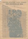
| Description: | This map shows the Wisconsin Central Railroad land grant lands owned and for sale by the Soo Line in Ashland County, Wisconsin, as well as in portions of B... |

| Date: | 1890 |
|---|---|
| Description: | This 1890s map shows the Wisconsin Central Railroad land grant lands owned and for sale by the Soo Line in Ashland County, Wisconsin, as well as in the eas... |

| Date: | 1890 |
|---|---|
| Description: | View from the shore of Kenosha's North Pier and lighthouse. Waves are breaking on the shore of Lake Michigan. |

| Date: | 1890 |
|---|---|
| Description: | Thirteen men and boys pose in a line with their bicycles. Most of the group poses with similar bicycles, except for one man standing with a penny-farthing ... |

| Date: | 1890 |
|---|---|
| Description: | This late 19th century map shows sections, state lands, Barre Center P.O. (now Barre Mills), railroads, topography, and streams and wetlands in the Town of... |

| Date: | 1890 |
|---|---|
| Description: | Shows towns of Dane County, lakes, rivers, and railroads. Relief shown by hachures. Includes color illustration of Madison and text describing Dane County ... |

| Date: | 1890 |
|---|---|
| Description: | This late-19th century map of Dane County, Wisconsin, shows the township and range grid, towns, sections, cities and villages, lakes and streams, roads, an... |

| Date: | 1890 |
|---|---|
| Description: | This map of Douglas County, Wisconsin, published around the beginning of the 20th century shows the copper bearing formations in the county on a map that a... |
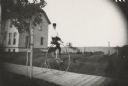
| Date: | 1890 |
|---|---|
| Description: | Young man riding a High Wheel or Penny-Farthing bicycle on a wooden sidewalk. There is a house behind the rider on the left. A young tree braced with a sta... |

| Date: | 1890 |
|---|---|
| Description: | Map of Milwaukee as remembered by "Dr Enoch Chase, U.B. Smith & Others." Represented are major roads, lowlands, trails, homesteads, and lots. Map depicts t... |
If you didn't find the material you searched for, our Library Reference Staff can help.
Call our reference desk at 608-264-6535 or email us at: