 Filter: Categories of Wisconsin Historical Images
Filter: FULL_DATE of 1890
Filter: Subject of ships
Filter: Categories of Wisconsin Historical Images
Filter: FULL_DATE of 1890
Filter: Subject of ships

| Date: | 1890 |
|---|---|
| Description: | Bird's-eye map of Ashland, viewed from Lake Superior, with insets of Prentice Park and Fishery. Population 16,000. Increase in Ten Years, 11,000. |

| Date: | 1890 |
|---|---|
| Description: | Bird's-eye map of West Superior and Superior, with insets of Wright Farm and First Building in Superior. |
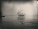
| Date: | 1890 |
|---|---|
| Description: | Schooner coming into Manitowoc harbor. |

| Date: | 1890 |
|---|---|
| Description: | Exterior of building, with arched main entrance. The road in front is crowded with pedestrians, trolleys, and horse-drawn vehicles. On the left is a boat ... |
| Date: | 1890 |
|---|---|
| Description: | Elevated view of brewing company and surrounding roads. On the road in front of the buildings are horse-drawn carts carrying barrels, a trolley car, and pe... |

| Date: | 1890 |
|---|---|
| Description: | Dow Flour Mill letterhead, with an engraving of the mill building, with a locomotive, a ship on the lake, and the dome of the Wisconsin State Capitol. |
If you didn't find the material you searched for, our Library Reference Staff can help.
Call our reference desk at 608-264-6535 or email us at: