 Filter: Categories of Wisconsin Historical Images
Filter: FULL_DATE of 1890
Filter: Subject of rivers
Filter: Categories of Wisconsin Historical Images
Filter: FULL_DATE of 1890
Filter: Subject of rivers

| Date: | 1890 |
|---|---|
| Description: | Portion of the plat map of the north part of Caledonia in Columbia County, including explanations. |

| Date: | 1890 |
|---|---|
| Description: | Plat map of the south part of Caledonia in Columbia County. |

| Date: | 1890 |
|---|---|
| Description: | Bird's-eye map of Beloit with insets of Williams Engine Works, Eclipse Wind Engine Co., and John Foster & Co. Turtle Creek is in the lower section, and the... |
| Date: | 1890 |
|---|---|
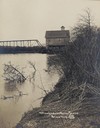
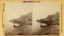
| Description: | Trempealeau River and its banks, with a building and bridge in the background. Caption reads: "Trempealeau River Scene, Blair, Wis." |
| Date: | 1890 |
|---|---|
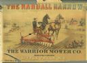
| Description: | Advertisement for the Randall Harrow, manufactured by the Warrior Mower Company. Features a color illustration of a farmer using the harrow in a field. |
| Date: | 1890 |
|---|---|
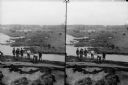
| Description: | Stereograph view of the Merrimac and Monitor Naval Battle cyclorama, painted by Théophile Poilpot. Men are standing on a riverbank in the foreground, and a... |

| Date: | 1890 |
|---|---|
| Description: | Left half of a plat map of the "East Part of the city of Madison". |
| Date: | 1890 |
|---|---|
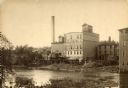
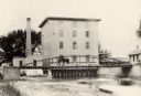
| Description: | View across water towards the Empire Mill. Alongside the building are railroad cars at a loading dock. The signs on the mill read: "Globe", "Globe's Empire... |
| Date: | 1890 |
|---|---|
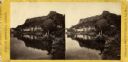
| Description: | A stereograph of Trempealeau from the river. |
| Date: | 1890 |
|---|---|
| Description: | Stereograph of Trempealeau from the river with two men in a boat in the foreground. |
| Date: | 1890 |
|---|---|
| Description: | Stereograph of Big Manitou Falls on the Black River. This waterfall reportedly was called "Gitchee Monido" by the Ojibwa, which means "Falls of the Great S... |

| Date: | 1890 |
|---|---|
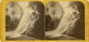
| Description: | Big Manitou Falls on the Black River. This waterfall reportedly was called "Gitchee Monido" by the Ojibwa, which means "Falls of the Great Spirit." |
| Date: | 1890 |
|---|---|
| Description: | View towards the mill on the Yahara River at the outlet of Lake Mendota. The mill was built in 1850 by Governor Farwell. A man is standing on the bridge wi... |

| Date: | 1890 |
|---|---|
| Description: | Exterior of building, with arched main entrance. The road in front is crowded with pedestrians, trolleys, and horse-drawn vehicles. On the left is a boat ... |

| Date: | 1890 |
|---|---|
| Description: | This map shows lakes, railroads, and rivers. An explanation of railroad lines with mileage in Wisconsin and total mileage for 1890 is included. Portions of... |
| Date: | 1890 |
|---|---|
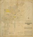
| Description: | Assessors plat of the city, including the Fox River. |
| Date: | 1890 |
|---|---|
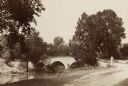
| Description: | Site of the Battle of Antietam, the Burnside Bridge. |
If you didn't find the material you searched for, our Library Reference Staff can help.
Call our reference desk at 608-264-6535 or email us at:


